레우바아
Le'auva'a레우바아 | |
|---|---|
마을 | |
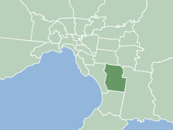
 레우바아 사모아의 위치 | |
| 좌표:13°48′00″S 171°52′19″w/13.80000°S 171.87194°W좌표: 13°48′00″S 171°52′19″W / 13.80000°S 171.87194°W | |
| 나라 | |
| 구 | 가가마에마우가 |
| 인구 (2016) | |
| • 합계 | 3,274 |
| 시간대 | -11 |
레우바아("배에서 온 사람들")는 사모아의 [1]우폴루 섬에 있는 마을이다.인구는 3274명이다.[2]
면적이 5.558km에2 [3]달하는 이 마을은 지리적으로 우폴루(Upolu)에 위치하지만,[4] 이웃 마을인 살레모아(Saleimoa)와 마찬가지로 사바이이(Savai'i) 섬의 가가마우가(그리고 역사적으로) 정치구역의 일부분이다.이 마을은 1905년 -1911년 마타바누 화산 폭발 때 우폴루로 이주한 사람들에 의해 세워졌으며, 르아우바아는 마우가와 사말래줄루에서 온 마을 사람들에 의해 세워졌다.[1]
살라무마는 우폴루 섬에 있는 또 다른 정착지로, 화산 폭발 후 사바이이 섬에서 이주하기도 했다.
레우바아는 사가가 3의 선거구(faipule district)에 속한다.[5]
참조
- ^ a b Fepuleai, Aleni; Weber, Eberhard; Nemeth, Karoly; Muliaina, Tolu (2016). "Eruption Styles of Samoan Volcanoes Represented in Tattooing, Language and Cultural Activities of the Indigenous People". Geoheritage. 9 (3): 395-411. doi:10.1007/s12371-016-0204-1. Retrieved 30 July 2021.
- ^ "Census 2016 Preliminary count" (PDF). Samoa Bureau of Statistics. Retrieved 3 August 2021.
- ^ [1], 56페이지
- ^ "Samoa Territorial Constituencies Act 1963". Pacific Islands Legal Information Institute. Archived from the original on 5 June 2011. Retrieved 15 December 2009.
- ^ "Electoral Constituencies Act 2019" (PDF). Parliament of Samoa. 31 January 2019. Retrieved 11 September 2021.
전통의 중심지: 살라울라 | ||
| 마을 |  | |
| 랜드마크 | ||
| 보존과 환경 | ||
| 교육 & 학교 | ||
| 선거구:파이풀 구 |
| |