클루티나 강
Klutina River| 클루티나 강 | |
|---|---|
 클루티나 강 | |
| 위치 | |
| 나라 | 미국 |
| 주 | 알래스카 |
| 인구 조사 지역 | 발데스-코르도바 |
| 물리적 특성 | |
| 출처 | 클루티나 빙하 |
| • 위치 | 추가치 산맥 |
| • 좌표 | 61°23′54″N 146°07′33″W/61.39833°N 146.12583°W[1] |
| • 고도 | 2,287ft(697m)[2] |
| 입 | 코퍼 강 |
• 위치 | 코퍼 센터 |
• 좌표 | 61°57′19″N 145°17′09″w/61.95528°N 145.2883°W좌표: 61°57′19″N 145°17′09″W / 61.95528°N 145.2883°W/ [1] |
• 고도 | 961ft(293m)[1] |
| 길이 | 63mi(101km)[1] |
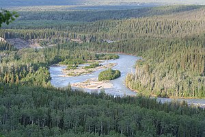
클루티나 강(Ahtna의 Tl'ati Na')은 미국 알래스카 주 코퍼 강의 63마일(101km) 지류다.[1][3][4]추가치 산맥의 클루티나 빙하를 시작으로, 강은 일반적으로 북동쪽으로 흐르며, 클루티나 호수를 지나 카퍼센터 공동체의 더 큰 강을 만난다.[5]강 어귀는 발데즈 북동쪽 66마일(106km)이다.[1]
낚시
코퍼 센터, 클루티나 강과 그 지류를 통과하는 리처드슨 고속도로에서 접근 가능한, 소키 연어와 트로피 크기의 킹 연어의 주요 어장이며, 후자의 무게는 때때로 50-90파운드(23~41kg)이다.[6]카퍼센터와 클루티나 호수 사이의 플로트플레인과 제트보트, 산책로, 개선되지 않은 사륜구동도로는 수역의 게임 피쉬에 대한 추가적인 접근을 제공한다.연어 외에 주요 종은 돌리 바덴과 북극 그레이링이다.[6]
참고 항목
참조
- ^ a b c d e f "Klutina River". Geographic Names Information System. United States Geological Survey. March 31, 1981. Retrieved December 19, 2013.
- ^ Google 어스에 소스 좌표를 입력하여 파생.
- ^ "Advanced Hydrologic Prediction Service: Anchorage: Klutina River at Copper Center". National Weather Service. Retrieved September 10, 2008.
- ^ "State's Title to Submerged Lands Beneath the Klutina River Documented" (PDF). Alaska Department of Law. September 15, 2004. Retrieved September 10, 2008.
- ^ Alaska Atlas & Gazetteer (7th ed.). Yarmouth, Maine: DeLorme. 2010. pp. 85–86. ISBN 978-0-89933-289-5.
- ^ a b Limeres, Rene; Pedersen, Gunnar; et al. (2005). Alaska Fishing: The Ultimate Angler's Guide (3rd ed.). Roseville, California: Publishers Design Group. pp. 309–10. ISBN 1-929170-11-4.


