블랙포드 백국
County of Blachford| 블랙포드 사우스오스트레일리아 주 | |||||||||||||||
|---|---|---|---|---|---|---|---|---|---|---|---|---|---|---|---|
 플린더 산맥 서쪽 끝에 있는 호커 북쪽의 버려진 집 | |||||||||||||||
 블랙포드 | |||||||||||||||
| 좌표 | 31°444141sS 138°07′14§ E/31.744627°S 138.120668°E좌표: 31°44°41°S 138°07°14°E / 31.744627°S 138.120668°E / [1] | ||||||||||||||
| 설립된 | 1877년 1월[2] 18일 | ||||||||||||||
| 지역 | 2,940 평방 킬로미터 (1,135 평방 마일)[1] | ||||||||||||||
| 위치 | 포트 오거스타에서 90km(56mi) NE | ||||||||||||||
| LGA | 플린더스 산맥 평의회[1] 목축 비법인 지역[1] | ||||||||||||||
| 지역 | 극북[1] | ||||||||||||||
| |||||||||||||||
| 각주 | 장소[1] 인접[3] 국가 | ||||||||||||||
블래치포드 카운티는 호주 사우스오스트레일리아주에 위치한 지적 단위로, 포트 오거스타에서 북동쪽으로 약 90km(56mi) 떨어진 토렌스 호수의 동쪽 해안과 플린더스 산맥의 서쪽 사이에 위치하고 있습니다.그것은 1877년에 선포되었고 1860년부터 1871년까지 식민지 부장관이었던 제1대 블라크포드 남작 프레데릭 로저스의 이름을 따서 명명되었다.반디오타, 코타베나, 와라킴보, 원오카, 울랴나 등 수백 개의 하위 단위로 부분적으로 나뉘었다.
묘사
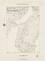
블래치포드 카운티는 토렌스 호수의 동쪽 해안에서 플린더스 산맥의 북쪽 경계를 따라 약 40km(25mi)에 이르는 사우스오스트레일리아의 일부에 걸쳐 있으며, 그 북쪽 [1]경계 남쪽으로 약 50km(31mi)에 걸쳐 있다.북동쪽으로 톤턴, 동쪽으로 핸슨, 남동쪽으로 그랜빌, 남쪽으로 [1][3]뉴스카슬과 접해 있다.
카운티는 동쪽에 플린더스 산맥의 일부와 서쪽에 [1]있는 토렌스 호수로 흘러드는 범람원으로 구성된 물리적 경관을 가지고 있다.
카운티의 주요 도시는 남동쪽 [1]구석에 위치한 호커이다.
카운티에는 아웃백 고속도로라는 주요 도로가 하나 있는데, 아웃백 고속도로는 카운티를 남쪽의 Quorn에서 북쪽의 Parchilna까지 수백 개의 Wonoka와 Woolyana를 통해 지나갑니다.아웃백 하이웨이는 [1]호커 남쪽 고속도로와 만나는 RM 윌리엄스 웨이(Williams Way)로부터의 교통량도 공급되고 있습니다.
Marree 철도는 수백 개의 Warrakimbo, Barndiooota 및 Cotebena를 [1]통해 남쪽에서 북동쪽으로 카운티를 통과합니다.
카운티는 주의 비법인 목회 지역과 플린더스 산맥 평의회 지방 정부 지역 내에 위치하고 있으며, 플린더스 산맥 평의회는 남동쪽 [1]모서리를 차지하고 있다.
카운티 내의 토지 이용은 가축, 광업 및 관광이 지배하는 농업과 관련이 있습니다.'목장 비법인 지역'과 '플린더스 산맥 평의회'에 대해 주정부가 발표한 요건은 '양립할 수 없는 토지 사용에 의한 침탈'을 방지하고 '농촌 경관의 질'을 보호하기 위해 토지 이용과 관련 개발을 통제하고자 한다.토지는 Marree 철도 노선의 서쪽에 있으며, Marree 철도 노선은 각각 '파스토랄'로 구분되어 있으며, '1차 생산'은 풍력 발전 등의 개발을 고려할 수 있는 기본 요건이다.철도 노선의 동쪽에 대한 토지 이용 및 관련 개발은 "지역의 [4][1][5]자연적 특성과 환경"을 보존하고 보호하기 위해 보다 고도로 통제되거나 일부 상황에서는 금지됩니다.
역사
블랙포드 백국은 1877년 [2][1]1월 18일에 선포되었다.이것은 1860년부터 [1][6]1871년까지 식민지 부장관이었던 제1대 Blachford 남작 Frederic Rogers의 이름을 따서 지어졌다.
1877년 원오카, 1880년 울랴나, 1881년 반디오타, 1888년 [7]코타베나, 와라킴보 등 수백 개가 군내에 선포되었다.
구성 수백
수백 개의 장소
핸슨 백작과의 경계에서 동서로 수백 개가 다음과 같이 [3]두 줄로 배열되어 있다.
- 울랴나와 코타베나로 구성된 북쪽 줄과
- 원오카, 반디오타, 와라킴보로 이루어진 남쪽 열
수백 개의 총 면적은 카운티의 총 면적 2,940 평방 킬로미터 중 2,140 평방 킬로미터(826 평방 마일)로 카운티 [1][8][9][10][11][12]면적의 72.8%를 차지합니다.
반디오타 백인
반디오타 백년(31°51ota31 (S 138°10 188125 1881E / 31.858607°S 138.173527°E / )은 1881년 3월 3일에 공포되었다.면적은 490평방킬로미터(188평방마일)에 이르며, 그 이름은 "1851년 휴 프로비가 '반두투 달리기'에서 유래한 원주민 단어"라는 설명과 함께 의미를 알 수 없는 원주민 단어에서 유래한 것으로 전해지고 있다.그 경계는 반디오타 [8][6][13]지역의 경계와 일치한다.
코타베나의 백인
의 Cotabena 100은 1888년 12월 에 선포되었다면적은 490km2, 이름은 1860년대 R.B. 스미스가 '에어산 워라킴보'에서 운영하던 양떼(임대번호 1659호)에서 따온 원주민 이름"이라고 한다.플린더스 [9][14][15]산맥의 남서쪽 구석에 완전히 위치해 있습니다.
100 오브 워라킴보
(31°51 188838 decemberS 138°001313eE/31.860556°S 138E은 1888년 12월 6일에 선포되었다.면적은 380평방킬로미터(147평방마일)이며, 그 이름은 "1860년대 R.B. 스미스가 가지고 있던 1659호 목축 임대 계약서에 적용된 원주민 단어에서 따온 것"으로 알려졌다.대부분의 지역은 왈러베르디나 지역에 위치해 있으며, 북쪽에는 레이크 토렌스 역이, [10][16][15]남쪽에는 야들말카가 있다.
원오카 백인
31°513131sS 138°212424eE / 31.85829°S 138E/ 은 1877년 1월 18일에 제정되었다.면적은 390평방킬로미터(151평방마일)에 달하며 이름은 1851년 존 맥킨레이가 운영하던 목사에 붙여진 '딸'이라는 뜻의 원주민 말로 알려졌다.그것은 완전히 호커 [11][16][2]지역의 서쪽 안에 위치해 있다.
울랴나 백인
울랴나 백년(31°372626sS 138°212121eE/31.62381°S 138.355893°E/ (면적은 390평방킬로미터(152평방마일)이며, 그 이름은 원주민 단어에서 유래했다.그것은 전적으로 [12][17]플린더스 산맥의 지역 경계 내에 위치해 있다.
갤러리
1882년 반디오타의 100명

코타베나의 100명, 1888년

워라킴보 100인, 1924년

원오카의 100인, 1964년

울랴나의 100인, 1964년
.jpg)
.jpg)
.jpg)
.jpg)
.jpg)
「 」를 참조해 주세요.
레퍼런스
- ^ a b c d e f g h i j k l m n o p q "Search result for "County of Blachford, Cnty" with the following layers selected - "Suburbs and Localities", "Local Government Areas", "Counties", "Hundreds", "Gazetteer", "Land Development Plan Zone Categories" and "Government Regions"". Location SA Map Viewer. Government of South Australia. Retrieved 26 January 2018.
- ^ a b c Ayers, Henry (18 January 1877). "untitled (proclamation of new counties and hundreds)" (PDF). The South Australian Government Gazette. Government of South Australia. 1877: 96–98. Retrieved 3 January 2018.
- ^ a b c "HUNDRED MAP Series Index Map" (PDF). Department of Environment and Heritage, Government of South Australia. December 2008. Retrieved 3 January 2018.
- ^ "Development Plan - Land Not Within a Council Area (Flinders) Consolidated – 29 November 2012" (PDF). Government of South Australia. 29 November 2012. pp. 1, 5, 40, 43, 45, 61, 62 and 66. Retrieved 3 January 2018.
- ^ "Development Plan - The Flinders Ranges Council Consolidated – 20 June 2013" (PDF). Government of South Australia. 20 June 2013. pp. 96, 108, 139, 146 & 147. Retrieved 28 January 2018.
- ^ a b Manning, Geoffrey. "South Australian Names - B" (PDF). Manning Index of South Australian History. State Library of South Australia. Retrieved 26 January 2018.
- ^ Leadbeater, Maureen (2017). "Counties & Hundreds of South Australia". FamilyHistorySA. Retrieved 26 January 2018.
- ^ a b "Search result for "Hundred of Barndioota, Hd" with the following layers selected - "Suburbs and Localities", "Local Government Areas", "Counties", "Hundreds", "Gazetteer" and "Government Regions"". Location SA Map Viewer. Government of South Australia. Retrieved 26 January 2018.
- ^ a b "Search result for "Hundred of Cotabena, Hd" with the following layers selected - "Suburbs and Localities", "Local Government Areas", "Counties", "Hundreds", "Gazetteer" and "Government Regions"". Location SA Map Viewer. Government of South Australia. Retrieved 26 January 2018.
- ^ a b "Search result for "Hundred of Warrakimbo, Hd" with the following layers selected - "Suburbs and Localities", "Local Government Areas", "Counties", "Hundreds", "Gazetteer" and "Government Regions"". Location SA Map Viewer. Government of South Australia. Retrieved 26 January 2018.
- ^ a b "Search result for "Hundred of Wonoka, Hd" with the following layers selected - "Suburbs and Localities", "Local Government Areas", "Counties", "Hundreds", "Gazetteer" and "Government Regions"". Location SA Map Viewer. Government of South Australia. Retrieved 26 January 2018.
- ^ a b "Search result for "Hundred of Woolyana, Hd" with the following layers selected - "Suburbs and Localities", "Local Government Areas", "Counties", "Hundreds", "Gazetteer" and "Government Regions"". Location SA Map Viewer. Government of South Australia. Retrieved 26 January 2018.
- ^ Morgan, William (3 March 1881). "untitled (proclamation of new hundreds)" (PDF). The South Australian Government Gazette. Government of South Australia. 1881 (52): 686–687. Retrieved 26 January 2018.
- ^ Manning, Geoffrey. "South Australian Names - C" (PDF). Manning Index of South Australian History. State Library of South Australia. Retrieved 26 January 2018.
- ^ a b Ramsay, J.G. (6 December 1888). "untitled (proclamation of new hundreds)" (PDF). The South Australian Government Gazette. Government of South Australia. 1888 (52): 1347. Retrieved 26 January 2018.
- ^ a b Manning, Geoffrey. "South Australian Names - W" (PDF). Manning Index of South Australian History. State Library of South Australia. Retrieved 26 January 2018.
- ^ Morgan, William. (5 August 1880). "untitled (proclamation of new hundreds)" (PDF). The South Australian Government Gazette. Government of South Australia. 1880 (32): 437–438. Retrieved 26 January 2018.


