그림 위드 저수지
Grimwith Reservoir| 그림 위드 저수지 | |
|---|---|
 북쪽 해안의 폐허에서 바라본 그림위드 저수지의 풍경. | |
 그림 위드 저수지 | |
| 위치 | 요크셔 달레스, 영국 |
| 좌표 | 54°04′48″N 01°54′41″W/54.08000°N 1.91139°W좌표: 54°04′48″N 01°54′41″W / 54.08000°N 1.91139°W |
| 유형 | 저수지 |
| 일차유입 | Blea Beck, Gate Up Gill, Grimwith Beck |
| 일차 유출 | 뎁 강 |
| 유역 면적 | 25.5km2(9.8제곱 mi) |
| 분지 국가 | 영국 |
| 표면적 | 1.47km2(0.57 sq mi) |
| 평균 깊이 | 14.8m(49ft)[1] |
| 수량 | 21,772,000m3(4.789×10imp9 gal) |
| 지표면 표고 | 288m(945ft) |
그림위드 저수지는 영국 노스요크셔의 요크셔 달즈에 위치해 있다.브래드포드 사가 원래 요크셔 달즈의 11개 저수지의 하나로 브래드포드 사에 담수를 공급하기 위해 건설한 것이다.저수량 기준으로 요크셔워터가 보유한 가장 큰 저수지다.애플트리윅, 번스올, 하틀링턴, 헤브덴, 스카이홀름의 마을 근처에 있다.
역사
그림위드(Grim'ath로 발음됨)[2]는 헤브덴에서 동쪽으로 1.5마일(2.4km) 떨어진 B6265 도로와 파텔리 브리지에서 서쪽으로 13km 떨어진 곳에서 접근한다.표면적이 1.47 평방 킬로미터(0.57 평방 mi)이고 21,772,000 입방 미터(4.789×10⁹ imf gal)의 물을 보유하고 있는 요크셔 워터 최대의 저수지다.[3]
원래의 저수지는 브래드포드 시의 지방 당국인 브래드포드 사에 의해 1864년에 완성되었고, 102에이커에 걸쳐 있었으며, 최대 6억 7천만 갤런이 들어 있었으며, 와르페데일의 해발 약 288미터(945피트)의 높이였다.[3][4]여기에는 저수지 일부로서 침수될 그림위드와 게이트 업의 햄릿을 유기하는 일이 포함되었다.그림위드는 보관을 위해 쓰이기보다는 보상저수지가 될 생각이었고, 브래드포드 코퍼드가 건설한 11개 저수지 가운데 그림위드는 브래드포드 타운센터(당시 브래드포드, 아직 도시가 아니었다)에서 가장 멀리 떨어져 있었다.[5]1970년 합의에 따라 저수지 규모는 7배, 수위는 20m(66ft)가량 높아졌으며 1976년부터 공사를 시작해 1983년 완공됐다.[6]저수지 콘센트는 연간 1400MWh의 전기를 발생시키는 소형 터빈을 설치한 신재생에너지 프로젝트의 현장이다.[7]
이 저수지는 새들에게 중요한 지역이며 유라시아 위건, 차, 회색 거위, 캐나다 거위 등의 야생조류가 서식하고 있다.[8]이 지역에서 다양한 시기에 볼 수 있는 다른 새들로는 고리무늬 물떼새, 북방 가로채기, 흔한 붉은색 갈매기, 갈대부엉이, 작은 붉은색 올빼미, 흰갈매기, 그리고 세지 워블러가 있다.[9]
이 저수지는 항해, 산책, 스텀프 크로스 동굴 방문객과 같은 레저 활동으로 인기 있는 곳이다.[3][8]휠체어로 접근할 수 있는 7.2km(4.5마일)의 도보/트랙이 저수지를 순환한다.[10][11]요크셔 달레스 요트 클럽은 저수지의 남쪽에 시설을 갖추고 [12]있으며 정기적으로 회의와 요트 대회를 연다.2019년, 그 클럽은 왕립 요트 협회로부터 공인 훈련 센터 지위를 받았다고 발표했다.[13]
저수지 동쪽 끝에는 2등급의 헛간이 있다.크록반(Cruck Bann)은 예전에는 더 서쪽이었으나, 그것을 보존하기 위해 현재의 수선 위의 부지에 재건되었다.이런 종류의 헛간은 요크셔 달레스에게는 드물다.그것의 기원은 16세기에 있었고, 저수지가 확장된 1982년에 재건되었다.[14][15]
갤러리

북쪽 그림위드 댐 확장파라펫
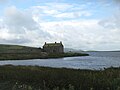
그림위드 하우스, 동쪽으로부터, 암초는 저 너머에 있다.

NW, 저수지 건너 브라센 호로 향하는 늦여름 풍경

2등급은 그림위드 저수지에 있는 크랙 헛간을 나열했다.
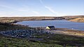
그림위드의 요크셔 달레스 요트 클럽

그림위드 주변의 오솔길


참조
- ^ "Grimwith Reservoir". Catchment Data Explorer. Environment Agency. Archived from the original on 8 August 2016. Retrieved 6 June 2016.
- ^ Smith, Jonathan (16 June 2018). "COUNTRY WALK: A circuit of Grimwith Reservoir". York Press. Archived from the original on 7 January 2019. Retrieved 7 January 2019.
- ^ a b c "Grimwith reservoir". Yorkshire Water. Archived from the original on 14 May 2009. Retrieved 22 August 2008.
- ^ The Surveyor and Municipal and County Engineer. 1922. p. 45. Retrieved 29 April 2019.
Grimwith reservoir was completed in 1864, and Chelker reservoir in 1866. ' The construction of the Horton Bank and Brayshaw service reservoirs and the Leeming and Leeshaw (compensation) reservoirs were authorised by the Act of 1868, ...
- ^ Dennison, Ed (January 2011). "Grimwith House, Grimwith Reservoir, Appletreewick, North Yorkshire; Architectural Assessment" (PDF). outofoblivion.org.uk. p. 5. Retrieved 7 January 2019.
- ^ "Craven Through The Years". Telegraph and Argus. 15 August 2008. Archived from the original on 8 December 2015. Retrieved 30 November 2015.
- ^ "Renewable energy". Archived from the original on 23 April 2012. Retrieved 12 October 2011.
- ^ a b "Grimwith Reservoir". Yorkshire Dales National Park Authority. Archived from the original on 13 May 2009. Retrieved 22 August 2008.
- ^ Smith, Jonathan (20 July 2018). "Peaceful circuit of reservoir". Darlington & Stockton Times. No. 29–2018. p. 61. ISSN 2516-5348.
- ^ "Walk 1573 – Grimwith Reservoir". Walking Britain. Archived from the original on 29 June 2016. Retrieved 6 June 2016.
- ^ Smith, Bob. "Dales 'missing link' improved to help disabled visitors at Grimwith Reservoir". Grough. grough.co.uk. Archived from the original on 1 July 2016. Retrieved 6 June 2016.
- ^ Tate, Lesley (14 April 2016). "An easy walk round Grimwith Reservoir – and watch out for the spaceship". Craven Herald. Archived from the original on 7 January 2019. Retrieved 7 January 2019.
- ^ Chapman, Hannah, ed. (27 December 2019). "Club shortlisted for award". Darlington & Stockton Times. No. 52–2019. p. 64. ISSN 2516-5348.
- ^ "Out of Oblivion: A landscape through time". outofoblivion.org.uk. Archived from the original on 4 April 2016. Retrieved 7 January 2019.
- ^ Historic England. "Grimwith High Laithe (Grade II) (1131787)". National Heritage List for England. Retrieved 7 January 2018.
외부 링크
- 요크셔 워터 – 그림 위드 저수지
- 도보길
- 요크셔 달레스 요트 클럽