푸에르토리코 쿨브라 플라멩코
Flamenco, Culebra, Puerto Rico플라멩코 | |
|---|---|
바리오 | |
 쿨브라의 다이빙 | |
 Culebra 시내의 플라멩코의 위치 | |
 플라멩코 푸에르토리코의 쿨레브라 위치 | |
| 좌표:18°19′08″N 65°21′12″w/18.318995°N 65.353463°W좌표: 18°19′08″N 65°21′12″W / 18.318995°N 65.353463°W/ [1] | |
| 영연방 | |
| 시 | |
| 면적 | |
| • 합계 | 76.77 sq mi (1968.8km2) |
| • 육지 | 4.88 sq mi(12.6km2) |
| • 물 | 71.89 sq mi (1972.2km2) |
| 표고 | 0 ft(0m) |
| 인구 (2010) | |
| • 합계 | 1,048 |
| • 밀도 | 214.8/sq mi(82.9/km2) |
| 출처: 2010년 인구조사 | |
| 시간대 | UTC-4(AST) |
| 우편번호 | 00775 |
플라멩코는 푸에르토리코 쿠레브라 섬의 바리오이다.2010년의 인구는 1,048명이었다.[3][4][5]
| 역사인구 | |||
|---|---|---|---|
| 인구조사 | Pop. | %± | |
| 1930 | 256 | — | |
| 1940 | 174 | −32.0% | |
| 1950 | 45 | −74.1% | |
| 1980 | 262 | — | |
| 1990 | 598 | 128.2% | |
| 2000 | 885 | 48.0% | |
| 2010 | 1,048 | 18.4% | |
| 미국 십수년 인구[6] 조사 1899년 (1990년 ~[7] 1900년) 1910년[8] 1930-1950[9] 1980-2000[10] 2010[11] | |||
섹터
바리오스(약간 소규모 시민구획에 비유할 수 있는 것)[12]는 차례로 더 작은 지역 인구 밀집 지역/종파(sectores)라고 불리는 단일 지역으로 세분화된다.종파의 종류는 보통 부문별로, 우르바니자시온에서 재파르토, 바리아다에서 잔재까지 다양할 수 있다.[13][14][15]
플라멩코 바리오에는 다음과 같은 부문이 있다.[16]
엑텐시온 빌라 무녜코, 섹터 라스 델리아스, 섹터 레사카, 섹터 로마나, 섹터 빌라 플라멩코, 섹터 빌라 무녜코.
갤러리
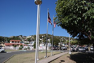
플라멩코의 거리 및 주택

타마린도 해수욕장의 거북이
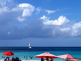
플라멩코 해변

플라멩코 해변의 부두


.jpg)

참고 항목
참조
- ^ a b "US Gazetteer 2019". US Census. US Government.
- ^ 미국 지질조사국 지리적 이름 정보 시스템:플라멩코바리오
- ^ Picó, Rafael; Buitrago de Santiago, Zayda; Berrios, Hector H. Nueva geografía de Puerto Rico: física, económica, y social, por Rafael Picó. Con la colaboración de Zayda Buitrago de Santiago y Héctor H. Berrios. San Juan Editorial Universitaria, Universidad de Puerto Rico,1969.
- ^ Gwillim Law (20 May 2015). Administrative Subdivisions of Countries: A Comprehensive World Reference, 1900 through 1998. McFarland. p. 300. ISBN 978-1-4766-0447-3. Retrieved 25 December 2018.
- ^ Puerto Rico:2010:population and housing unit counts.pdf (PDF). U.S. Dept. of Commerce, Economics and Statistics Administration, U.S. Census Bureau. 2010.
- ^ "U.S. Decennial Census". United States Census Bureau. Archived from the original on February 13, 2020. Retrieved September 21, 2017.
- ^ "Report of the Census of Porto Rico 1899". War Department Office Director Census of Porto Rico. Archived from the original on July 16, 2017. Retrieved September 21, 2017.
- ^ "Table 3-Population of Municipalities: 1930 1920 and 1910" (PDF). United States Census Bureau. Archived (PDF) from the original on August 17, 2017. Retrieved September 21, 2017.
- ^ "Table 4-Area and Population of Municipalities Urban and Rural: 1930 to 1950" (PDF). United States Census Bureau. Archived (PDF) from the original on August 30, 2015. Retrieved September 21, 2014.
- ^ "Table 2 Population and Housing Units: 1960 to 2000" (PDF). United States Census Bureau. Archived (PDF) from the original on July 24, 2017. Retrieved September 21, 2017.
- ^ Puerto Rico:2010:population and housing unit counts.pdf (PDF). U.S. Dept. of Commerce Economics and Statistics Administration U.S. Census Bureau. 2010. Archived (PDF) from the original on 2017-02-20. Retrieved 2019-08-02.
- ^ "US Census Barrio-Pueblo definition". factfinder.com. US Census. Archived from the original on 13 May 2017. Retrieved 5 January 2019.
- ^ "Agencia: Oficina del Coordinador General para el Financiamiento Socioeconómico y la Autogestión (Proposed 2016 Budget)". Puerto Rico Budgets (in Spanish). Retrieved 28 June 2019.
- ^ Rivera Quintero, Marcia (2014), El vuelo de la esperanza: Proyecto de las Comunidades Especiales Puerto Rico, 1997-2004 (first ed.), San Juan, Puerto Rico Fundación Sila M. Calderón, ISBN 978-0-9820806-1-0
- ^ "Leyes del 2001". Lex Juris Puerto Rico (in Spanish). Retrieved 24 June 2020.
- ^ "PRECINTO ELECTORAL CULEBRA 097" (PDF). Comisión Estatal de Elecciones (in Spanish). PR Government. 7 November 2018. Retrieved 24 June 2020.
외부 링크

