드그레이프너드 공원 역사 구역
DeGraffenried Park Historic District드그레이프너드 공원 역사 구역 | |
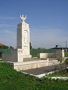
 DeGraffenry 공원 역사 구역, 2012년 10월 | |
  | |
| 위치 | Neuse Blvd, Fort Totten Dr, Trent Rd., Chattawka Ln, North Carolina, New Bern, North Bern에 의해 대략 경계. |
|---|---|
| 좌표 | 35°6′27″N 77°3′38″w/35.10750°N 77.06056°W좌표: 35°6′27″N 77°3′38″W / 35.10750°N 77.06056°W |
| 면적 | 21에이커(8.5 ha) |
| 빌드됨 | 1927 |
| 건축가 | Fusson, Raymond; Hines, B.G. 등. |
| 건축양식 | 식민지 부흥, 튜더 부흥 등. |
| NRHP 참조 | 06000689[1] |
| NRHP에 추가됨 | 2006년 8월 9일 |
드그레이퍼너드 공원 역사 지구는 노스캐롤라이나 주 크레이븐 카운티 뉴 베른에 위치한 국가 역사 지구다.그것은 1926년에서 1956년 사이에 개발된 뉴 베른의 주택 구역에 86개의 기여 건물과 1개의 기여 부지를 포함한다.이 지역은 식민지 부흥과 튜더 부흥 양식의 주거지가 특징이다.이 지역에 위치한 곳은 드그레이프너드 공원이 위치한 곳이다.[2]
참조
- ^ a b "National Register Information System". National Register of Historic Places. National Park Service. July 9, 2010.
- ^ M. Ruth Little (December 2005). "DeGraffenried Park Historic District" (pdf). National Register of Historic Places - Nomination and Inventory. North Carolina State Historic Preservation Office. Retrieved 2014-08-01.
| 주제 |  | |
|---|---|---|
| 목록 군별로 |
| |
| 기타 목록 | ||