코아모바리오푸에블로
Coamo barrio-pueblo코아모바리오푸에블로 푸에블로 데 코아모 | |
|---|---|
시립석[1] | |
 | |
 Coamo 시내의 Coamo Barrio-pueblo 위치(빨간색 표시) | |
 코아모바리오푸에블로 푸에르토리코의 위치 | |
| 좌표:18°04′42″N 66°21′36″w/18.078375°N 66.360068°W좌표: 18°04′42″N 66°21′36″W / 18.078375°N 66.360068°W[2] | |
| 영연방 | |
| 시 | |
| 면적 | |
| • 합계 | 0.89 sq mi(2.3 km2) |
| • 육지 | 0.89 sq mi(2.3 km2) |
| • 물 | 0 sq mi(0km2) |
| 표고 | 397 ft (1987 ft) |
| 인구 (2010) | |
| • 합계 | 6,685 |
| • 밀도 | 7,511.2/sq mi(2,900.1/km2) |
| 출처: 2010년 인구조사 | |
| 시간대 | UTC-4(AST) |
코아모바리오푸에블로(Coamo Barrio-pueblo)는 푸에르토리코 시 자치구인 코아모의 행정중심지(좌석)이다.2010년의 인구는 6,685명이다.[1][4][5][6]
스페인의 관습대로 푸에르토리코에는 중앙 광장과 시립 건물(시청), 가톨릭 교회가 들어 있는 푸에블로라는 바리오가 있다.매년 중앙광장에서 피에스타 후원회가 열린다.[7][8]
| 역사인구 | |||
|---|---|---|---|
| 인구조사 | Pop. | %± | |
| 1980 | 10,244 | — | |
| 1990 | 9,026 | −11.9% | |
| 2000 | 7,573 | −16.1% | |
| 2010 | 6,685 | −11.7% | |
| 미국 십수년 인구[9] 조사 1899년 (1990년 ~[10] 1900년) 1910년[11] 1930-1950[12] 1980-2000[13] 2010[14] | |||
중앙광장과 그 교회
중앙광장, 즉 광장은 공식 및 비공식 레크리에이션 행사를 위한 바리오푸에블로(barrio-pueblo)의 장소로서 해질 무렵부터 새벽까지 사람들이 모여 어울릴 수 있는 곳이다.19세기 초 푸에르토리코에서의 생활을 규제한 인디아 법, 스페인 법은 광장의 목적이 "당사자"(연예, 축제)를 위한 것이며(스페인어: 프로포시토 파라 라스 피에스타), 광장은 이웃(스페인어:그란데자 프로포르시오나다 알 누에로)에 비례하여 넓어야 한다고 명시하였다. 베시노스이 스페인 규정들은 또한 근처의 거리는 지나가는 사람들을 위한 편안한 포탈이어야 하며, 그들을 태양과 비라는 요소로부터 보호해야 한다고 명시했다.[7]
코아모 바리오푸에블로 중앙광장 건너편에 로마 가톨릭 교회인 파로키아 산 블라스 데 일레스카스가 있다.[15]
갤러리
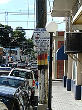
코아모바리오푸에블로 주의 거리

코아모바리오푸에블로 주의 거리

코아모 푸에블로 산블라스 데 일레스카스 교회
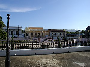
Coamo의 주요 광장 또는 마을 광장의 전경.

푸에르토리코에서 가장 오래된 거리 중 하나인 발도리티 거리.

할리우드 극장


참고 항목
참조
- ^ a b Puerto Rico:2010:population and housing unit counts.pdf (PDF). U.S. Dept. of Commerce, Economics and Statistics Administration, U.S. Census Bureau. 2010.
- ^ a b "US Gazetteer 2019". US Census. US Government.
- ^ 미국 지질조사국 지리적 이름 정보 시스템:코아모바리오푸에블로
- ^ Picó, Rafael; Buitrago de Santiago, Zayda; Berrios, Hector H. (1969). Nueva geografía de Puerto Rico: física, económica, y social, por Rafael Picó. Con la colaboración de Zayda Buitrago de Santiago y Héctor H. Berrios. San Juan Editorial Universitaria, Universidad de Puerto Rico,1969.
- ^ Gwillim Law (20 May 2015). Administrative Subdivisions of Countries: A Comprehensive World Reference, 1900 through 1998. McFarland. p. 300. ISBN 978-1-4766-0447-3. Retrieved 25 December 2018.
- ^ "US Census Barrio-Pueblo definition". factfinder.com. US Census. Archived from the original on 13 May 2017. Retrieved 5 January 2019.
- ^ a b Santullano, Luis A. (10 March 2019). Mirada al Caribe. Vol. 54. Colegio de Mexico. pp. 75–78. doi:10.2307/j.ctvbcd2vs.12. JSTOR j.ctvbcd2vs.12.
- ^ Pariser, Harry S. (2003). Explore Puerto Rico, Fifth Edition. San Francisco: Manatee Press. pp. 52–55. Retrieved 10 February 2019.
- ^ "U.S. Decennial Census". United States Census Bureau. Archived from the original on February 13, 2020. Retrieved September 21, 2017.
- ^ "Report of the Census of Porto Rico 1899". War Department Office Director Census of Porto Rico. Archived from the original on July 16, 2017. Retrieved September 21, 2017.
- ^ "Table 3-Population of Municipalities: 1930 1920 and 1910" (PDF). United States Census Bureau. Archived (PDF) from the original on August 17, 2017. Retrieved September 21, 2017.
- ^ "Table 4-Area and Population of Municipalities Urban and Rural: 1930 to 1950" (PDF). United States Census Bureau. Archived (PDF) from the original on August 30, 2015. Retrieved September 21, 2014.
- ^ "Table 2 Population and Housing Units: 1960 to 2000" (PDF). United States Census Bureau. Archived (PDF) from the original on July 24, 2017. Retrieved September 21, 2017.
- ^ Puerto Rico:2010:population and housing unit counts.pdf (PDF). U.S. Dept. of Commerce Economics and Statistics Administration U.S. Census Bureau. 2010. Archived (PDF) from the original on 2017-02-20. Retrieved 2019-08-02.
- ^ Mari Mut, José A. (2013-08-28). Los Pueblos de Puerto Rico y Las Iglesias de Sus Plazas [The Pueblos of Puerto Rico, and the Churches of its Plazas] (PDF) (in Spanish). Archived (PDF) from the original on 2020-12-14. Retrieved 2021-09-16.
외부 링크


