구름크로프트 피크
Cloudcroft Peaks| 구름크로프트 피크 | |
|---|---|
 두 가지 약에서 본 먼 구름크로프트 봉우리들의 꼭지점 | |
| 최고점 | |
| 표고 | 8,714ft(2,656m)[1] |
| 두각을 나타남 | 1,210 ft(m)[1] |
| 좌표 | 48°26′02″N 113°34′08″w / 48.43389°N 113.56889°W좌표: 48°26′02″N 113°34′08″W / 48.43389°N 113.5689°W/ [2] |
| 지리 | |
 구름크로프트 피크 몬태나 주의 위치  구름크로프트 피크 미국의 위치 | |
| 위치 | 미국 몬태나 주 플랫헤드 카운티 |
| 상위 범위 | 루이스 레인지 |
| 토포 지도 | USGS 마운트 세인트 니콜라스, MT |
Cloudcroft Peaks (8,714피트 (2,656m))는 미국 몬태나 주에 있는 빙하 국립공원의 루이스 레인지에 위치해 있다.[3]
기후
Cloudcroft Peaks는 길고, 보통 매우 추운 겨울과 짧고, 시원하고, 온화한 여름으로 특징지어지는 고산성 아북극 기후 지역에 위치해 있다.[4] 겨울 온도는 -10°F 미만으로 떨어질 수 있으며, 바람의 냉기 계수는 -30°F 미만으로 떨어질 수 있다.
지질학
빙하 국립공원의 다른 산들과 마찬가지로, 구름크로프트 봉우리는 프레암브리아에서 쥐라기 시대에 놓여진 퇴적암으로 이루어져 있다. 얕은 바다에서 형성된 이 퇴적암은 1억 7천만년 전 루이스 오버러스트 단층이 백악기의 어린 바위 위로 3mi(4.8km) 두께, 50마일(80km) 폭, 160마일(260km) 길이의 거대한 석판을 밀었을 때 처음 상승하였다.[5]
갤러리
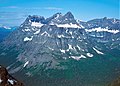
동쪽면
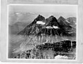
에어리얼 뷰, 1925년 경


참고 항목
참조
- ^ a b "Cloudcroft Peaks, Montana". Peakbagger.com. Retrieved August 2, 2017.
- ^ "Cloudcroft Peaks". Geographic Names Information System. United States Geological Survey. Retrieved August 2, 2017.
- ^ Mount Saint Nicholas, MT (Map). TopoQwest (United States Geological Survey Maps). Retrieved December 28, 2018.
- ^ Peel, M. C.; Finlayson, B. L.; McMahon, T. A. (2007). "Updated world map of the Köppen−Geiger climate classification". Hydrol. Earth Syst. Sci. 11 (5): 1633–1644. Bibcode:2007HESS...11.1633P. doi:10.5194/hess-11-1633-2007. ISSN 1027-5606.
- ^ Gadd, Ben (2008). "Geology of the Rocky Mountains and Columbias".
{{cite journal}}: Cite 저널은 필요로 한다.journal=(도움말)


