체스터 히스토리 구
Chester Historic District체스터 히스토리 구 | |
,_Chester,_South_Carolina.jpg) 체스터 카운티 법원 | |
  | |
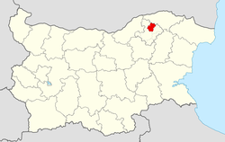
| 위치 | jct를 중심으로 한 상업지역.미국 321번과 SC 72번(원래)과 Hemphill Ave, Brawley, Saluda, FootESts에 의해 대략 경계되고 Redy St. (증가), South Carolina, Chester, Chester, South St. |
|---|---|
| 좌표 | 34°42′20″N 81°12′55″w/34.70556°N 81.21528°W좌표: 34°42′20″N 81°12′55″W / 34.70556°N 81.21528W/ |
| 면적 | 300에이커(120 ha) 250에이커(100 ha) 증가 |
| 건축가 | 착륙선, 프레드; 에트알(증가) |
| 건축양식 | 그리스 부흥, 고딕, 로마네스크(원래) 및 고전 부흥, 그리스 부흥, 후기 빅토리아(증가) |
| NRHP 참조 | 72001203[1](원래) 87000684[1] (1994년) |
| 중요일자 | |
| NRHP에 추가됨 | 1972년 6월 13일 |
| 경계증가 | 1988년 3월 15일 |
사우스캐롤라이나주 체스터의 체스터 히스토리 지구는 1972년 국가역사유적지구에 등재된 역사지구다.[1][2][3][4]
그 지역에는 324개의 기부 재산이 있다.

참조
- ^ a b c "National Register Information System". National Register of Historic Places. National Park Service. July 9, 2010.
- ^ Caughman, Wright (January 30, 1987). "City of Chester Historic District" (pdf). National Register of Historic Places - Nomination and Inventory. Retrieved 23 June 2012.
- ^ Black, David R. (May 18, 1972). "Chester Historic District (Revision)" (pdf). National Register of Historic Places - Nomination and Inventory. Retrieved 23 June 2012.
- ^ "Chester Historic District, Chester County (Chester)". National Register Properties in South Carolina. South Carolina Department of Archives and History. Retrieved 23 June 2012.
| 주제 |  | |
|---|---|---|
| 목록 군별로 | ||
| 도시별 목록 | ||
| 기타 목록 | ||
사우스캐롤라이나 체스터 카운티의 한 재산에 관한 이 기사는 단편적이다.위키피디아를 확장하여 도울 수 있다. |