미주리 주 캐롤턴
Carrollton, Missouri미주리 주 캐롤턴 | |
|---|---|
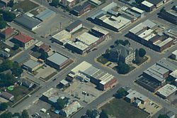
 미주리 캐럴턴 항공전 | |
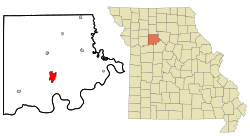
 미주리 주 캐롤튼의 위치 | |
| 좌표: 39°21′32″N 93°29′44″w / 39.3589°N 93.49556°W좌표: 39°21′32″N 93°29′44″W / 39.35889°N 93.49556°W/ | |
| 나라 | 미국 |
| 주 | 미주리 주 |
| 카운티 | 캐럴 |
| 정부 | |
| • 유형 | 시장협의회 |
| • 시장 | 프랭크 올베라 |
| 면적 | |
| • 합계 | 4.18 sq mi(10.84 km2) |
| • 육지 | 4.17 sq mi(10.80 km2) |
| • 물 | 0.02 sq mi(0.04km2) |
| 표고 | 755피트(230m) |
| 인구 (2020) | |
| • 합계 | 3,514 |
| • 견적 (2019)[2] | 3,476 |
| • 밀도 | 833.97/sq mi (1983.97/km2) |
| 시간대 | UTC-6(중앙(CST)) |
| • 여름(DST) | UTC-5(CDT) |
| 우편번호 | 64633 |
| 지역 번호 | 660 |
| FIPS 코드 | 29-11566[3] |
| GNIS 피쳐 ID | 0715434[4] |
| 웹사이트 | 시 웹사이트 |
캐롤튼(Carrollton)은 미국 미주리 주 캐롤 카운티에 있는 도시다. 캐롤튼은 내셔널 시빅 리그가 매년 수여하는 2005 올 아메리칸 시티 상을 수상했다. 2020년 인구조사 때 인구는 3,514명이었다.[5] 캐롤튼은 캐롤 카운티의 군청이다.[6]
역사
캐롤튼은 1833년에 설립되었다.[7] 그것은 1834년에 우체국을 얻었다.[8] 캐롤튼의 성장은 산본 지도를 통해 기록될 수 있으며, 그 중 몇 가지는 온라인에서 이용할 수 있다.[9]
캐롤 카운티 법원 하우스, 캐롤 카운티 보안관 숙소와 교도소, 미국 우체국, 윌콕슨과 컴퍼니 뱅크 등이 국가 사적지 등록부에 등재되어 있다.[10]
지리
캐롤튼은 39°22에 위치해 있다.′N 93°30′W / 39.367°N 93.500°W/ (39.3589,[11] -93.4956) 미국 인구조사국에 따르면 이 도시의 총 면적은 4.19제곱마일(10.85km2)이며, 이 중 4.17제곱마일(10.80km2)은 육지, 0.02제곱마일(0.05km2)은 물이다.[12]
기후
| 미주리주 캐롤튼에 대한 기후 데이터(1991-2020 정상, 극단 1893–현재) | |||||||||||||
|---|---|---|---|---|---|---|---|---|---|---|---|---|---|
| 월 | 얀 | 2월 | 3월 | 4월 | 5월 | 준 | 줄리 | 8월 | 9월 | 10월 | 11월 | 12월 | 연도 |
| 높은 °F(°C) 기록 | 74 (23) | 80 (27) | 87 (31) | 93 (34) | 98 (37) | 105 (41) | 114 (46) | 108 (42) | 105 (41) | 94 (34) | 81 (27) | 73 (23) | 114 (46) |
| 평균 높은 °F(°C) | 37.2 (2.9) | 42.6 (5.9) | 54.5 (12.5) | 65.7 (18.7) | 75.3 (24.1) | 84.3 (29.1) | 88.0 (31.1) | 86.7 (30.4) | 79.8 (26.6) | 67.8 (19.9) | 53.6 (12.0) | 41.8 (5.4) | 64.8 (18.2) |
| 일평균 °F(°C) | 27.3 (−2.6) | 31.9 (−0.1) | 42.7 (5.9) | 53.5 (11.9) | 64.1 (17.8) | 73.6 (23.1) | 77.5 (25.3) | 75.7 (24.3) | 67.7 (19.8) | 55.6 (13.1) | 42.7 (5.9) | 32.1 (0.1) | 53.7 (12.1) |
| 평균 낮은 °F(°C) | 17.4 (−8.1) | 21.1 (−6.1) | 31.0 (−0.6) | 41.3 (5.2) | 52.9 (11.6) | 62.9 (17.2) | 67.0 (19.4) | 64.7 (18.2) | 55.5 (13.1) | 43.4 (6.3) | 31.8 (−0.1) | 22.5 (−5.3) | 42.6 (5.9) |
| 낮은 °F(°C) 기록 | −23 (−31) | −34 (−37) | −16 (−27) | 14 (−10) | 28 (−2) | 41 (5) | 47 (8) | 42 (6) | 28 (−2) | 17 (−8) | −5 (−21) | −24 (−31) | −34 (−37) |
| 평균 강수량 인치(mm) | 1.41 (36) | 1.85 (47) | 2.51 (64) | 3.92 (100) | 5.13 (130) | 5.37 (136) | 4.27 (108) | 4.39 (112) | 4.28 (109) | 3.16 (80) | 2.21 (56) | 1.58 (40) | 40.08 (1,018) |
| 평균 강설 인치(cm) | 4.8 (12) | 3.3 (8.4) | 1.1 (2.8) | 0.2 (0.51) | 0.0 (0.0) | 0.0 (0.0) | 0.0 (0.0) | 0.0 (0.0) | 0.0 (0.0) | 0.3 (0.76) | 0.9 (2.3) | 2.1 (5.3) | 12.7 (32) |
| 평균 강수일수(평균 0.01인치) | 5.6 | 5.5 | 8.6 | 10.5 | 12.1 | 10.1 | 8.4 | 8.3 | 7.5 | 8.6 | 6.5 | 5.6 | 97.3 |
| 평균 눈 오는 날(0.1인치) | 2.3 | 1.8 | 0.6 | 0.1 | 0.0 | 0.0 | 0.0 | 0.0 | 0.0 | 0.1 | 0.4 | 1.9 | 7.2 |
| 출처: NOAA[13][14] | |||||||||||||
인구통계학
| 역사인구 | |||
|---|---|---|---|
| 인구조사 | Pop. | %± | |
| 1860 | 738 | — | |
| 1870 | 1,832 | 148.2% | |
| 1880 | 2,313 | 26.3% | |
| 1890 | 3,878 | 67.7% | |
| 1900 | 3,854 | −0.6% | |
| 1910 | 3,452 | −10.4% | |
| 1920 | 3,218 | −6.8% | |
| 1930 | 4,058 | 26.1% | |
| 1940 | 4,070 | 0.3% | |
| 1950 | 4,380 | 7.6% | |
| 1960 | 4,554 | 4.0% | |
| 1970 | 4,847 | 6.4% | |
| 1980 | 4,700 | −3.0% | |
| 1990 | 4,406 | −6.3% | |
| 2000 | 4,122 | −6.4% | |
| 2010 | 3,784 | −8.2% | |
| 2019년(최상) | 3,476 | [2] | −8.1% |
| 미국 십수년 인구[15] 조사 | |||
교육
캐롤튼 R-VII 학군은 캐롤튼 지역 진로센터, 캐롤튼 고등학교, 9-12학년, 캐롤튼 중학교, 7-8학년, 캐롤튼 초등학교, 2-6학년, 아담스쿨, 프리 K-1학년 등을 운영하고 있다.[16]
그 마을에는 대출 도서관인 캐롤튼 공공 도서관이 있다.[17]
저명인사
- 토머스 아치볼드, 미군 대령, 베트남 참전 용사. 1958-1980. 1980-2002년 대학 부총장
- 화가 겸 조각가[18] 아만다 오스틴
- UAW 리더 리언 E. 베이츠
- 제임스 H. 1972년부터 1976년까지 루이지애나 공화당의 의장인 보이스는 1922년 캐롤튼에서 태어나 1990년 배턴 루즈에서 사망했다.
- 제임스 존슨 두더슈타트 미시건 대학 총장. 1988-1996
- 제임스 퍼거슨, 1952년에 캐롤튼 고등학교를 졸업했다. 미국의 발명가이자 사업가인. 국립 발명가 명예의 전당 회원. LCD를 개선한 액정화면(Liquid Crystal Display. 그는 사망 당시 100개가 넘는 미국 특허를 보유하고 있었다.
- 프란치스코 도일 글리슨 로마 가톨릭 주교
- 돈 마틴, 예일대 출신 수비수 부카네어, 치프스, 패트리어츠를 위해 NFL에서 뛰었고, 오클랜드 레이더스를 위해 NFL에서 코치했다.
- 캠프 르쥔과 캠프 펜들턴의 건설에 관여했던 USMC의 존 C. 맥퀸 소령; 2차 세계대전의 훈장 노장.
- 남북전쟁의 장군이자 미국 상원의원인 제임스 실즈
- 로버트 심슨, 로버트 잉걸스 "밥" 심슨은 미국의 허들러이자 육상 코치였다. 심슨은 120yd 허들에서 여러 개의 세계 신기록을 세웠고 220yd 허들에서 세계 신기록을 세웠고 1919년 인터앨리어드 게임에서 두 개의 금메달을 땄다. 심슨은 캐롤튼 근처의 보즈워스에 있는 가족 농장에서 자랐다. 그는 삼형제 중 맏며느리였고 육상 가족의 일원이었다. 심슨의 동생 존과 쿤시는 그들의 사촌인 윌리엄 실베스터와 마찬가지로 심슨의 뒤를 따랐다.
- 클로드 T. 스미스, 미국의 밴드 지휘자, 작곡가, 교육자.
- 조조 삼손, 솥뚜껑 록밴드의 리드싱어
참조
- ^ "2019 U.S. Gazetteer Files". United States Census Bureau. Retrieved July 26, 2020.
- ^ a b "Population and Housing Unit Estimates". United States Census Bureau. May 24, 2020. Retrieved May 27, 2020.
- ^ "U.S. Census website". United States Census Bureau. Retrieved 2008-01-31.
- ^ "US Board on Geographic Names". United States Geological Survey. 2007-10-25. Retrieved 2008-01-31.
- ^ "Explore Census Data". data.census.gov. Retrieved 2021-12-23.
- ^ "Find a County". National Association of Counties. Archived from the original on 2011-05-31. Retrieved 2011-06-07.
- ^ "Carroll County Place Names, 1928–1945 (archived)". The State Historical Society of Missouri. Archived from the original on 24 June 2016. Retrieved 10 September 2016.CS1 maint: bot: 원래 URL 상태를 알 수 없음(링크)
- ^ Earngey, Bill (1995). Missouri Roadsides: The Traveler's Companion. University of Missouri Press. p. 38. ISBN 9780826210210.
- ^ 미주리를 위한 산본 지도: 미주리 대학교 디지털 도서관 캐롤튼. 2011-03-14 액세스
- ^ "National Register Information System". National Register of Historic Places. National Park Service. July 9, 2010.
- ^ "US Gazetteer files: 2010, 2000, and 1990". United States Census Bureau. 2011-02-12. Retrieved 2011-04-23.
- ^ "US Gazetteer files 2010". United States Census Bureau. Archived from the original on 2012-07-02. Retrieved 2012-07-08.
- ^ "NowData – NOAA Online Weather Data". National Oceanic and Atmospheric Administration. Retrieved August 2, 2021.
- ^ "Station: Carrollton, MO". U.S. Climate Normals 2020: U.S. Monthly Climate Normals (1991-2020). National Oceanic and Atmospheric Administration. Retrieved August 2, 2021.
- ^ "Census of Population and Housing". Census.gov. Retrieved June 4, 2015.
- ^ "Schools". Carrollton R-VII School District. Retrieved 23 March 2018.
- ^ "Missouri Public Libraries". PublicLibraries.com. Archived from the original on 10 June 2017. Retrieved 23 March 2018.
- ^ Eleanor Tufts; National Museum of Women in the Arts (U.S.); International Exhibitions Foundation (1987). American women artists, 1830–1930. International Exhibitions Foundation for the National Museum of Women in the Arts. ISBN 978-0-940979-01-7.
외부 링크
- 캐롤튼 지역 상공회의소
- 미주리 대학교 미주리 컬렉션의 산본 지도에 나타난 캐롤튼의 역사적 지도


