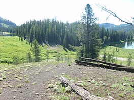
보니 호
Bonny Lakes| 보니 호 | |
|---|---|
 서쪽 호수와 동쪽 호수 모두 | |
 두 호수 중에서 더 서쪽이다. | |
| 위치 | 미국 오리건 주 월로와 카운티 이글 캡 와일드 |
| 좌표 | 45°11′01″N 117°09′40″W/45.1834889°N 117.1610013°W좌표: 45°11′01″N 117°09′40″W / 45.1834889°N 117.1610013W/ [1] |
| 유형 | 연못 |
| 일차유입 | 빅 썸 크릭 |
| 일차 유출 | 빅 썸 크릭 |
| 분지 국가 | 미국 |
| 최대 길이 | 서호: 195yd(178m) 동호: 189yd(173m) |
| 최대폭 | 서호: 189yd(173m) 동호: 80yd(73m) |
| 평균 깊이 | 서호: 6피트(1.8m) 동호: 4피트(1.2m) |
| 지표면 표고 | 7,840ft(2,840m)[2] |
보니 레이크는 미국 오레곤주 북동부의 이글 캡 황야지에 위치한 두 개의 작고 얕은 산 연못이다.그들은 달러 호수에서 동쪽으로 약 2마일 떨어진 [3]보니 레이크 분지로 알려진 아네로이드 산의 큰 초원에 위치해 있다.[4]그들은 함께 7,840피트(2,390m)의 이글 캡 황야에서 13번째로 높은 호수로 기록되어 있다.[2]
트레일
보니 레이크는 월로와 레이크 트레일헤드(여행 10마일) 또는 텐더풋 트레일헤드(여행 3.5마일) 중 하나로 접근할 수 있다.[5]호수는 1802번 길에 있다.
참고 항목
참조
- ^ "Bonny Lakes". Geographic Names Information System. United States Geological Survey. Retrieved 2008-11-21.
- ^ a b "Elevations of Points Near Eagle Cap Wilderness". Wallowa-Whitman National Forest. U.S. Forest Service. Archived from the original on 2008-09-17. Retrieved 2008-11-24.
- ^ "Petes Point". Peakware.com. Archived from the original on 2016-03-04. Retrieved 2009-03-03.
- ^ Barstad, Frank (2002). Hiking Oregon's Eagle Cap Wilderness. Morris Book Publishing.
- ^ "Bonny Lake Panorama". Archived from the original on 2008-07-05. Retrieved 2009-03-03.


