인디애나 주 블랑포드
Blanford, Indiana인디애나 주 블랑포드 | |
|---|---|
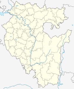
 인디아나주 버밀리언 카운티에 있는 블랑포드의 위치. | |
| 좌표:39°39′54″N 87°31′14″w/39.66500°N 87.52056°W좌표: 39°39′54″N 87°31′14″W / 39.66500°N 87.52056°W/ ; | |
| 나라 | 미국 |
| 주 | 인디애나 주 |
| 카운티 | 버밀리언 |
| 타운쉽 | 클린턴 |
| 표고 | 571ft(평방미터 m) |
| 시간대 | UTC-5(동부(EST)) |
| • 여름(DST) | UTC-4(EDT) |
| 우편번호 | 47842 |
| 지역 번호 | 765 |
| GNIS 피쳐 ID | 431177 |
블랑포드는 미국 인디애나주 버밀리언 카운티 클린턴 타운쉽에 있는 인구조사 지정지다.[2]
역사
Blanford는 1912년에 배치되었다.[3]이 공동체는 마을이 위치한 땅을 소유한 L. S. Blanford의 이름을 따서 지어졌다.[4]블랑포드에는 1915년부터 우체국이 운영되고 있다.[5]
지리
블랑포드는 39°393954″N 87°31′14″W / 39.66500°N 87.52056°W/ (39.665060, -87.520580)에 위치한다.
인구통계학
| 역사인구 | |||
|---|---|---|---|
| 인구조사 | Pop. | %± | |
| 미국 십수년 인구[6] 조사 | |||
참고 항목
참조
- ^ "US Board on Geographic Names". United States Geological Survey. October 25, 2007. Retrieved 2016-07-15.
- ^ "Blanford, Indiana". Geographic Names Information System. United States Geological Survey. Retrieved 2009-10-17.
- ^ Baker, Ronald L. (October 1995). From Needmore to Prosperity: Hoosier Place Names in Folklore and History. Indiana University Press. p. 68. ISBN 978-0-253-32866-3.
This village was platted on October 26, 1912...
- ^ Vermillion County Historical Society (Vermillion County, Ind.) (1990). Vermillion County, Indiana History and Families. Turner Publishing Company. p. 87. ISBN 978-0-938021-34-6.
- ^ "Vermillion County". Jim Forte Postal History. Retrieved 1 October 2015.
- ^ "Census of Population and Housing". Census.gov. Retrieved June 4, 2016.
| 일반 | |
|---|---|
| 국립도서관 | |
인디애나주 버밀리언 카운티의 이 기사는 단조롭다.위키피디아를 확장하여 도울 수 있다. |