바파틀라만달
Bapatla mandal바파틀라만달 | |
|---|---|
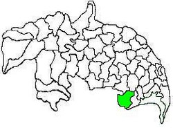
 군터 지구의 맨달 지도는 다음을 보여준다. Bapatla Mandal(녹색) | |
| 좌표:15°53~20°N 80°28°12°E/15.8889°N 80.47000°E좌표: 15°53°20°N 80°28°12°E / 15.8889°N 80.47000°E / | |
| 나라 | 인도 |
| 주 | 안드라프라데시 주 |
| 구 | 바파트라 |
| 본사 | 바파트라 |
| 정부 | |
| • 본체 | 만다 교구 |
| • 테실다르 | T. 발리아 |
| 지역 | |
| • 합계 | 233.91km2(90.31평방마일) |
| 인구. (2011년)[2] | |
| • 합계 | 143,825 |
| • 밀도 | 610/km2(1,600/160mi) |
| 언어들 | |
| 시간대 | UTC+5:30 (IST) |
Bapatla Mandal은 인도 Andhra Pradesh 주의 Bapatla 구역에 있는 25개의 맨달 중 하나입니다.이 회사는 테날리 수익부의 관리 하에 있으며 본사는 바파틀라에 [3][1]있습니다.맨달은 군투르 지역의 카쿠마누, 폰누르, 카라팔렘 맨달과 경계를 이룬다.또한 프라카삼 구와 국경을 접하고 있으며, 그 [4]일부는 벵골 만 연안에 있습니다.
인구 통계
2011년 인구 조사 기준으로[update] 맨달의 인구는 143,825명이다.총인구는 남성 70,847명, 여성 72,978명으로 남성 1000명당 여성 1030명의 성비이다.아이는 0~6세 연령대로 13,371명이며 이 중 남자 6856명, 여자 6515명이다.평균 문맹률은 71.79%이며 리터 수는 93,[2]653명이다.
결산
2011년 인구 조사 기준으로[update] 맨달에는 21개의 정착지가 있다.그것은 20개의 마을과 1개의 [5][6]바파틀라를 포함합니다.
맨달의 결산은 다음과 같습니다.
- 아디비
- 아피카트라
- 바파트라(M)
- 바파틀라 이스트 (농촌)
- 바파틀라 웨스트 (농촌)
- 바르티푸디
- 체루부
- Etheru(이더루)
- 고파푸람
- 구디푸디
- 잠물라팔렘
- 질렐라무디
- 칸카타팔렘
- 마루프로루바리팔렘(농촌)
- 물라팔렘
- 무루콘다파두
- 나라사야팔렘
- 네레두팔레
- 팔라파르티파두
- 푼드라
- 벨리체라
정부와 정치
맨달은 타실달의 지배하에 있으며 현재 타실달은 T이다.바랴[8]Bapatla Mandal은 Bapatla([9]의회 선거구) 아래에 있는 3개의 맨달 중 하나로, Andhra Pradesh의 Bapatla(SC)(록 사바 선거구)를 대표합니다.
「 」를 참조해 주세요.
레퍼런스
- ^ a b "District Census Hand Book : Guntur (Part B)" (PDF). Census of India. Directorate of Census Operations, Andhra Pradesh. 2011. pp. 14, 498. Retrieved 1 June 2019.
- ^ a b "Census 2011". The Registrar General & Census Commissioner, India. Archived from the original on 23 September 2015. Retrieved 16 October 2014.
- ^ "District Census Hand Book : Guntur (Part A)" (PDF). Census of India. Directorate of Census Operations, Andhra Pradesh. 2011. pp. 5, 830–831. Retrieved 1 June 2019.
- ^ "Mandals in Guntur district". aponline.gov.in. Archived from the original on 28 April 2015. Retrieved 10 September 2014.
- ^ "Guntur District Mandals" (PDF). Census of India. pp. 102, 112. Retrieved 19 January 2015.
- ^ "Sub-District Details of Guntur District". The Registrar General & Census Commissioner, India. Archived from the original on 15 April 2015. Retrieved 10 September 2014.
- ^ "Abbreviations used". censusindia.gov.in. Archived from the original on 17 June 2007. Retrieved 26 May 2014.
- ^ "List of Tahsildars working in Guntur District as on 19.06.2014" (PDF). Guntur District Official Website. National Informatics Centre. p. 1. Archived from the original (PDF) on 16 October 2014. Retrieved 8 September 2014.
- ^ "Delimitation of Parliamentary and Assembly Constituencies Order, 2008" (pdf). Election Commission of India. p. 22. Retrieved 11 October 2014.


