캔자스 주 발라
Bala, Kansas캔자스 주 발라 | |
|---|---|
 | |
| 좌표:39°18′35″N 96°56′59″W/39.30972°N 96.94972°W좌표: 39°18′35″N 96°56′59″W / 39.30972°N 96.94972°W[1] | |
| 나라 | 미국 |
| 주 | 캔자스. |
| 카운티 | 라일리 |
| 설립됨 | 1862 |
| 에 대해 명명됨 | 발라 |
| 표고 | 1,283ft(391m) |
| 인구 | |
| • 합계 | 29 |
| 시간대 | UTC-6(CST) |
| • 여름(DST) | UTC-5(CDT) |
| 지역번호 | 785 |
| FIPS 코드 | 20-03800 [1] |
| GNIS ID | 476196 [1] |
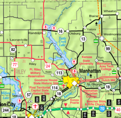
발라(Bala)는 미국 캔자스 주 라일리 카운티 발라 타운쉽에 있는 비법인 공동체다.[1]2020년 인구조사를 기준으로 지역사회와 인근 지역의 인구는 29명이다.[2]
역사
발라는 1862년경에 정착했다.시카고, 록아일랜드, 퍼시픽 철도의 선적 지점이었다.[3]그것은 웨일스의 발라에서 이름을 따왔다.[4]
1871년 발라에 우체국이 개설되어 1966년 단종될 때까지 계속 운영되었다.[5]
인구통계학
| 역사인구 | |||
|---|---|---|---|
| 인구조사 | Pop. | %± | |
| 2020 | 29 | — | |
| 미국 십수년 인구 조사 | |||
미국 인구조사국은 통계를 위해 발라를 인구조사 지정 장소(CPP)로 규정했다.
교육
이 커뮤니티는 라일리 카운티 USD 378 공립학교 구역에서 서비스된다.
참조
- ^ a b c d e "Bala, Kansas", Geographic Names Information System, United States Geological Survey
- ^ a b "Profile of Bala, Kansas (CDP) in 2020". United States Census Bureau. Archived from the original on April 26, 2022. Retrieved April 26, 2022.
- ^ Blackmar, Frank Wilson (1912). Kansas: A Cyclopedia of State History, Embracing Events, Institutions, Industries, Counties, Cities, Towns, Prominent Persons, Etc. Standard Publishing Company. pp. 132.
- ^ "Profile for Bala, Kansas". ePodunk. Retrieved 22 June 2014.
- ^ "Kansas Post Offices, 1828-1961". Kansas Historical Society. Archived from the original on October 9, 2013. Retrieved 22 June 2014.
추가 읽기
외부 링크


