일리헤르메
Ylihärmä일리헤르메 | |
|---|---|
구 시 | |
| 이흐흐메르만쿤타 이흐흐메코문 | |
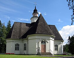
 일레르메 교회 | |
 핀란드의 일리헤르메 | |
| 좌표:63°08.5˚N 022°47.5′E/63.1417°N 22.7917°E좌표: 63°08.5′N 022°47.5′E / 63.1417°N 22.7917°E | |
| 나라 | 핀란드 |
| 지역 | 남부 오스트로보트니아 |
| 하위 영역 | 흐르만마아 하위 지역 |
| 설립됨 | 1868 |
| 통합 | 2009 |
| 면적 | |
| • 합계 | 152.17km2(58.75제곱 mi) |
| • 육지 | 151.7km2(58.6제곱 mi) |
| • 물 | 0.47km2(0.18제곱 mi) |
| 인구 (2008-12-31)[2] | |
| • 합계 | 2,916 |
| • 밀도 | 19/km2(50/sq mi) |
| 연령별 인구 [3]> | |
| • 0 ~ 14 | 18.1% |
| • 15-64 | 59.8% |
| • 65세 이상 | 22.1% |
| 시간대 | UTC+2(EET) |
| • 여름(DST) | UTC+3(EEST) |
일리헤르메는 핀란드의 전 자치 단체다.2009년 1월 1일 알라흐마메, 코르테샤르비 등과 함께 카우하바로 통합되었다.
서핀란드 지방에 위치하고 있으며 남부 오스트로보트니아 지역에 속해 있다.이 시군은 2,916명(2008년 12월 31일 기준)[2]의 인구를 가지고 있으며, 면적은 151.70 평방 킬로미터(58.57 평방 미)이다.[1]인구 밀도는 평방 킬로미터 당 19.22명의 거주자였다.
그 자치단체는 이상하게도 핀란드인이었다.
참조
- ^ a b "Area by municipality as of 1 January 2008" (PDF) (in Finnish and Swedish). Land Survey of Finland. Retrieved 20 January 2011.
- ^ a b "Population by municipality as of 31 December 2008". Population Information System (in Finnish and Swedish). Population Register Center of Finland. Archived from the original on 2011-07-20. Retrieved 20 January 2011.
- ^ "Population according to age and gender by area as of 31 December 2007". Statistics Finland's PX-Web databases. Statistics Finland. Retrieved 1 January 2009.[영구적 데드링크]
- ^ "Population according to language and the number of foreigners and land area km2 by area as of 31 December 2008". Statistics Finland's PX-Web databases. Statistics Finland. Retrieved 29 March 2009.[영구적 데드링크]
외부 링크
![]() 위키미디어 커먼스의 일리함마 관련 매체
위키미디어 커먼스의 일리함마 관련 매체


