퀸즐랜드 주 우드힐
Woodhill, Queensland| 우드힐 퀸즐랜드 주 로건시티 | |||||||||||||||
|---|---|---|---|---|---|---|---|---|---|---|---|---|---|---|---|
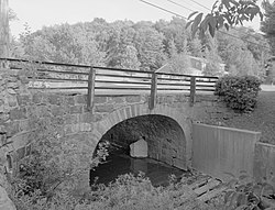
 로건 강, 2016 | |||||||||||||||
 우드힐 | |||||||||||||||
| 좌표 | 27°53′07″S 152°58′24″E/27.882°S 152.9733°E좌표: 27°53′07″S 152°58′24″E / 27.8852°S 152.9733°E/ | ||||||||||||||
| 인구 | 723(2016년 인구조사)[1] | ||||||||||||||
| • 밀도 | 53.96/km2 (1987.7/sq mi) | ||||||||||||||
| 우편번호 | 4285 | ||||||||||||||
| 면적 | 13.4km2(5.2제곱 mi) | ||||||||||||||
| 시간대 | 심미(UTC+10:00) | ||||||||||||||
| LGA | 로건시티 | ||||||||||||||
| 주 선거인단 | 경치림 | ||||||||||||||
| 연방 부서 | 장인 | ||||||||||||||
| |||||||||||||||
'우드힐은 오스트레일리아 퀸즐랜드 로건시에 있는 시골 지역이다.[2]2016년 인구조사에서 우드힐의 인구는 723명이었다.[1]
역사
타운스발레 국립학교는 1873년 6월 2일에 개교했다.1874년 1월 1일 베레스데일 주립학교가 되었다.1899년에 우드힐 주립학교로 개칭되었다.[3][4]
우드힐 역(27°535335″S 152°5)8′23″E / 27.8931°S 152.9731°E/ 은 베사니아에서 보데서트까지 사용되지 않는 보데서트 철도에 있었다.[5]이 노선은 1888년 5월 16일에 개통되었다.[6]
이전에 보데서트의 샤이어에서 있었던 우드힐은 2008년 3월 지방 정부 합병에 이어 로건 시의 일부가 되었다.
2011년 인구조사에서 우드힐의 인구는 423명이었다.[7]
2016년 인구조사에서 우드힐의 인구는 723명이었다.[1]
지리
도로 인프라
교육
우드힐 주립학교(Woodhill State School)는 린데세이 산 고속도로(Mount Lindesay Highway) 6027 (27°53s34 152S 152°5)에 있는 소년소학교(Prep-6)이다.8′25″E / 27.8929°S 152.9737°E/ )[9][10]2018년에는 교사 16명(정규직 14명)과 비교직원 13명(정규직 8명)으로 211명이 등록했다.[11]
참조
| 위키미디어 커먼즈에는 퀸즐랜드의 우드힐과 관련된 미디어가 있다. |
- ^ a b c Australian Bureau of Statistics (27 June 2017). "Woodhill (SSC)". 2016 Census QuickStats. Retrieved 20 October 2018.
- ^ "Woodhill – locality in City of Logan (entry 45298)". Queensland Place Names. Queensland Government. Retrieved 27 December 2020.
- ^ Queensland Family History Society (2010), Queensland schools past and present (Version 1.01 ed.), Queensland Family History Society, ISBN 978-1-921171-26-0
- ^ "Woodhill". Suburbs. Logan City Council. Archived from the original on 2 April 2015. Retrieved 6 May 2014.
- ^ "Woodhill – railway station in Logan City (entry 37974)". Queensland Place Names. Queensland Government. Retrieved 2 April 2020.
- ^ Kerr, John (1990). Triumph of narrow gauge : a history of Queensland Railways. Boolarong Publications. p. 224. ISBN 978-0-86439-102-5.
- ^ Australian Bureau of Statistics (31 October 2012). "Woodhill (SSC)". 2011 Census QuickStats. Retrieved 6 May 2014.
- ^ Google (15 September 2021). "Woodhill, Queensland" (Map). Google Maps. Google. Retrieved 15 September 2021.
- ^ "State and non-state school details". Queensland Government. 9 July 2018. Archived from the original on 21 November 2018. Retrieved 21 November 2018.
- ^ "Woodhill State School". Archived from the original on 27 July 2012. Retrieved 21 November 2018.
- ^ "ACARA School Profile 2018". Australian Curriculum, Assessment and Reporting Authority. Archived from the original on 27 August 2020. Retrieved 28 January 2020.