옐로우스톤 국립공원의 플라타우스
Plateaus of Yellowstone National Park
옐로우스톤 국립공원에는 9개의 지명 고지가 있다.이 고원은 훨씬 더 큰 옐로우스톤 고원의 일부분이며 갈라틴 산맥과 압사로카 산맥의 남쪽과 서쪽 공원의 지역을 지배하고 있다.고원 중 4개는 11만년에서 7만년 전에 발생한 운석 용암 흐름에서 나온 것이다.[1]
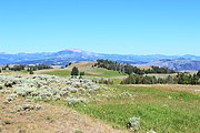
흑꼬리 사슴 고원에서 바라본 갈라틴 산맥

- 검은꼬리사슴고원44°55′28″N 110°34′05″W / 44.92444°N 110.56806°W/ [2] 7,113피트(2,168m)
- 버팔로 고원 44°59′47″N 110°14′46″W / 44.99639°N 110.24611°W/ [4] 8,251피트(2,515m)
- 중앙고원 44°35′49″N 110°37′44″W / 44.59694°N 110.62889°W/ [7] 8,399피트(2,560m)
- 매디슨 고원 44°21′02″N 110°58′18″W / 44.35056°N 110.97167°W/ [8] 8,435피트(2,571m)
- 매디슨 고원은 매디슨 강 남쪽, 어퍼 앤 로어 게이저 베이신스 서쪽의 지명 고원 중 가장 크다.매디슨 강에서 대륙 분단까지 남쪽으로 뻗어 있고, 서쪽으로 공원 경계선까지 뻗어 있다.정상호수탐방로인 단 하나의 산책로만이 고원을 동서로 가로지르기 때문에 고원은 사실상 접근이 불가능하다.페어리 크릭 트레일은 페어리 폭포와 리틀 파이어홀 메도우로 가는 길에 고원의 동쪽 가장자리를 관통한다.[9]
- 거울고원 44°43′55″N 110°07′32″W / 44.73194°N 110.1256°W/ ([10] 8,714피트(2,656m)

- 피치스톤 고원 44°15′11″N 110°46′24″W / 44.25306°N 110.773°W/ [12] 881피트(2707m)
- 솔파타라 고원 44°43′53″N 110°32′45″W / 44.73139°N 110.54583°W/ 고원),[13]8,166피트(2,489m)
- 트라이던트 고원 44°11′36″N 110°00′40″W / 44.1933°N 110.0111°W / ([16] 10,649피트(3,246m)
- 두 개의 해양고원 44°10′33″N 110°12′59″W / 44.17583°N 110.21639°W/ [18] 9,478피트(2,889m)
- 두 개의 대양 고원은 대륙 분열이 그 위를 가로지른다는 사실 때문에 이름이 붙여졌는데, 그 고원의 강수량은 태평양이나 멕시코만에 이른다.하나의 개울은 남쪽으로 흐르고 결국 물의 이별에서 갈라진다.

갤러리
옐로우스톤 국립공원의 플라타우스
블랙테일 고원

피치스톤 고원


참고 항목
메모들
- ^ Smith, Robert Baer (2000). Windows into the earth: the geologic story of Yellowstone and Grand Teton National Parks. New York: Oxford University Press. ISBN 0-19-510596-6.
- ^ "Blacktail Deer Plateau". Geographic Names Information System. United States Geological Survey.
- ^ Whittlesey, Lee H. (2006). Yellowstone Place Names. Gardiner, MT: Wonderland Publishing Company. p. 53. ISBN 1-59971-716-6.
- ^ "Buffalo Plateau". Geographic Names Information System. United States Geological Survey.
- ^ Whittlesey, Lee H. (2006). Yellowstone Place Names. Gardiner, MT: Wonderland Publishing Company. p. 58. ISBN 1-59971-716-6.
- ^ Trails Illustrated-Tower/Canyon, Yellowstone National Park (304) (Map) (Revised ed.). 1:63360. National Geographic Maps. 2008. ISBN 1-56695-435-5.
- ^ "Central Plateau". Geographic Names Information System. United States Geological Survey.
- ^ "Madison Plateau". Geographic Names Information System. United States Geological Survey.
- ^ Trails Illustrated-Old Faithful, Yellowstone National Park (302) (Map) (Revised ed.). 1:63360. National Geographic Maps. 2008. ISBN 1-56695-433-9.
- ^ "Mirror Plateau". Geographic Names Information System. United States Geological Survey.
- ^ Whittlesey, Lee H. (2006). Yellowstone Place Names. Gardiner, MT: Wonderland Publishing Company. p. 172. ISBN 1-59971-716-6.
- ^ "Pitchstone Plateau". Geographic Names Information System. United States Geological Survey.
- ^ "Solfatara Plateau". Geographic Names Information System. United States Geological Survey.
- ^ Whittlesey, Lee H. (2006). Yellowstone Place Names. Gardiner, MT: Wonderland Publishing Company. p. 233. ISBN 1-59971-716-6.
- ^ Trails Illustrated-Mammoth Hot Springs, Yellowstone National Park (303) (Map) (Revised ed.). 1:63360. National Geographic Maps. 2008. ISBN 1-56695-304-9.
- ^ "Trident Plateau". Geographic Names Information System. United States Geological Survey.
- ^ Whittlesey, Lee H. (2006). Yellowstone Place Names. Gardiner, MT: Wonderland Publishing Company. p. 252. ISBN 1-59971-716-6.
- ^ "Two Ocean Plateau". Geographic Names Information System. United States Geological Survey.


