타구팅가, 토칸틴스
Taguatinga, Tocantins타구잉가 | |
|---|---|
| 무니시피우 데 타구팅가 다구팅가 시 | |
| 닉네임: 타구아 | |
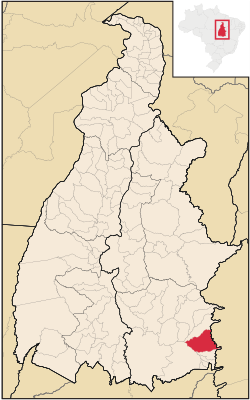
 토칸틴의 타구팅가 국산화 | |
| 좌표: 12°24′22″S 46°26′02″w / 12.40611°S 46.43389°W | |
| 나라 | |
| 지역 | 북부 주 |
| 주 | |
| 설립됨 | 1872년 6월 10일 |
| 정부 | |
| • 시장 | 알타미란도 즈이킨하 곤살베스 타구팅가(PV) (2017-2020) |
| 면적 | |
| • 합계 | 2.437386km2(0.941080 sq mi) |
| 표고 | 634m(2,080ft) |
| 인구 (2020 [1]) | |
| • 합계 | 16,825 |
| • 밀도 | 6.18/km2(16.0/sq mi) |
| 데모닉 | 타구팅우엔스 |
| 시간대 | UTC-3(UTC-3) |
| • 여름(DST) | UTC-2(UTC-2) |
| 우편 번호(CEP) | 77320-000 |
| 지역 번호 | +55 63 |
| 웹사이트 | www.taguatinga.to.gov.br |
타구잉타는 브라질의 토칸틴스 주에 있는 시이다.[2][3][4][5]
역사
이 구간은 비어 있다. 덧셈으로 도움받을 수 있다(2012년 12월) |
참고 항목
참조
- ^ "IBGE 2020". Retrieved 26 January 2021.
- ^ "Divisão Territorial do Brasil" (in Portuguese). Divisão Territorial do Brasil e Limites Territoriais, Instituto Brasileiro de Geografia e Estatística (IBGE). July 1, 2008. Retrieved December 17, 2009.
- ^ "Estimativas da população para 1º de julho de 2009" (PDF) (in Portuguese). Estimativas de População, Instituto Brasileiro de Geografia e Estatística (IBGE). August 14, 2009. Retrieved December 17, 2009.
- ^ "Ranking decrescente do IDH-M dos municípios do Brasil" (in Portuguese). Atlas do Desenvolvimento Humano, Programa das Nações Unidas para o Desenvolvimento (PNUD). 2000. Retrieved December 17, 2009.
- ^ "Produto Interno Bruto dos Municípios 2002-2005" (PDF) (in Portuguese). Instituto Brasileiro de Geografia e Estatística (IBGE). December 19, 2007. Retrieved December 17, 2009.
외부 링크
| 위키미디어 커먼즈에는 타구잉가, 토칸틴스와 관련된 미디어가 있다. |


