슈시커 (강)
Shushicë (river)| 슈시커 | |
|---|---|
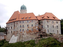
 그리버 산을 배경으로 한 슈시카(루미 이블로스)의 계곡. | |
 | |
| 위치 | |
| 나라 | 알바니아 |
| 물리적 특성 | |
| 출처 | |
| • 위치 | 블로러 현 |
| 입 | |
• 위치 | 조서 |
• 좌표 | 40°34′8″N 19°34′13″E / 40.56889°N 19.57028°E좌표: 40°34′8″N 19°34′13″E / 40.56889°N 19.57028°E/ |
| 길이 | 80km(50mi) |
| 분지형상 | |
| 진행 | 브조세→ 아드리아 해 |
슈시커 강(Shusicere or Vlora river)은 알바니아 남부에 있는 강으로, 보세 강의 지류다. 그 근원은 히마레 자치주 쿠스 마을 근처의 벨로러 카운티에 있다. 일반적으로 브라타지, 코터, 슈시커 등을 거쳐 북서쪽으로 흐르며, 브롤러 북동쪽의 아르메니아 부근에 있는 브조서로 흐른다.
강 계곡의 농업 용도는 매우 집약적이며, 수초에서 시작된다. 강을 따라 페슈케피, 드라쇼비치, 코테의 하류에는 지금까지 세 개의 다리가 있다.
제2차 세계대전의 그레코-이탈리아 전쟁 중이던 1940년 12월, 진격하는 그리스군은 히마라 함락으로 이어지는 성공적인 작전으로 이탈리아 부대를 밀어내고 슈시커 계곡으로 침투했다.[1] 1943년 말 그 지역은 드라쇼비카 전투의 전쟁터였다.
고대에는 강을 폴리아토스(그리스어: πούανςς)와 차오나이트(그리스어: χαοίηηηηηη)라고 불렀다.[2]
참조
- ^ An abridged history of the Greek-Italian and Greek-German war, 1940-1941: (land operations). Athens: Hellenic Army General Staff, Army History Directorate. 1997. p. 117.
The successful outcome of this battle was of particular importance, since the occupation of Koutsi saddle opened the road through the Siousitsa valley... After that, the Italians abandoned Himara, into which the Greek troops entered, in the morning of December 22.
- ^ Hammond, Nicholas Geoffrey Lemprière (1967). Epirus: the geography, the ancient remains, the history and topography of Epirus and adjacent areas. Clarendon P. p. 679.
The Polyanthus (Shushke) is called 'Chaonites' by Lycophron