세이 댐
Sei Dam| 세이 댐 | |
|---|---|
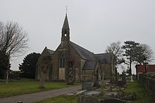
 세이댐 저수지 전경 | |
| 위치 | 라자스탄 우다이푸르 주 코트라테실 |
| 좌표 | 24°43°09°N 73°11′53″e/24.719217°N 73.8075°E좌표: 24°43°09°N 73°11°53°E / 24.719217°N 73.8075°E / |
| 공사가 시작되다 | 1968-69년[1] |
| 오퍼레이터 | 라자스탄 정부[2] |
| 댐 및 수로 | |
| 인바운드 | 세이 강 |
| 높이 | 28미터[2] |
| 길이 | 1453 m[2] |
| 여수로 용량 | 1756[2] 입방 미터/초 |
| 저장고 | |
| 총 용량 | 3,133만 입방[3] 미터 |
세이 댐(Sei Diversion[3] Dam이라고도 함)은 인도 라자스탄 우다이푸르 지역에 있는 코트라 테실의 사바르마티 강의 지류인 세이 강에 있는 토성 중력 댐이다.이 댐의 주된 목적은 [4]팔리 지역의 자와이 강에 있는 자와이 댐으로 우회할 물을 저장하는 것이다.
댐 현장의 세이 강의 유역 면적은 320 평방 킬로미터이다.[5]세이 댐의 건설은 1977년에 시작되어 1978년에[5][3] 4.07 크로르를 [6]들여 완성되었다.
레퍼런스
- ^ Sehgal, K.K. Gazetteer of India Rajasthan Pali. Jaipur: Directorate of District Gazetteers. Retrieved 24 May 2019.
- ^ a b c d "Sei Diversion Dam D00864". Water Resources Information System of India. Retrieved 3 May 2019.
- ^ a b c Sabarmati Basin. Government of India Ministry of Water Resources. 2014. Retrieved 3 May 2019.
- ^ Jain, Sharad K; Agarwal, Pushpendra K; Singh, Vijay P (2007). Hydrology and Water Resources of India. Springer. ISBN 9781402051807.
- ^ a b Application Of GIUH And GIS Based Approach For Design Flood Estimation. National Institute of Hydrology. 1998.
- ^ Major and Medium Irrigation Projects in India - Completed Projects Compiled Upto End of Ninth Plan Including Ongoing and New Projects of Tenth Plan. Central Water Commission. 2008.