우루과이 산자신토
San Jacinto, Uruguay샌재신토 | |
|---|---|
시구정촌 | |
 | |
| 좌표:34°33°0ºS 55°52′0″w/34.55000°S 55.86667°W좌표: 34°33°0°S 55°52°0°W / 34.55000°S 55.86667°W / | |
| 나라 | |
| 부서 | |
| 인구. (2011년 인구조사) | |
| • 합계 | 4,510 |
| 시간대 | UTC - 3 |
| 우편번호 | 91300 |
| 다이얼 플랜 | +598 4399(+4자리) |
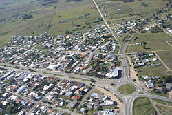
산 야신토는 우루과이 남부 카넬로네스 주에 있는 작은 도시입니다.
산자신토는 도시가 속한 도시의 이름이기도 하다.
위치
이 도시는 몬테비데오 중심에서 북동쪽으로 약 53km(33mi) 떨어진 11번 국도와 7번 국도의 교차로에 위치해 있습니다.
역사
1901년 6월 20일, 레이노 2.[1]700법에 의해 푸에블로(마을)로 승격되었다.1951년 6월 27일 레이노 11.689법에 의해 [2]"빌라"(Villa)(시)로 승격되었다.마침내 1976년 11월 26일, Ley N60 14.[3]605 법에 의해 시우다드(Ciudad, 도시)로 승격되었다.
인구.
2011년 인구 조사에 따르면, 샌재신토의 인구는 4,510명이다.[4]2010년 인텐텐시아 드 카넬로네스는 선거 [5]기간 동안 자치구의 인구를 7,052명으로 추산했다.
| 연도 | 인구. |
|---|---|
| 1908 | 4,616 |
| 1963 | 1,908 |
| 1975 | 2,244 |
| 1985 | 2,795 |
| 1996 | 3,596 |
| 2004 | 3,909 |
| 2011 | 4,510 |
자료 : 국립 우루과이 국립통계연구소 (Instituto National de Estadistica de[1] Uruida)에서 작성.
예배 장소
레퍼런스
- ^ a b "Statistics of urban localities (1908–2004)" (PDF). INE. 2012. Retrieved 9 September 2012.
- ^ "LEY N° 11.689". República Oriental del Uruguay, Poder Legislativo. 1951. Archived from the original on 4 March 2016. Retrieved 9 September 2012.
- ^ "Ley Nº 14.605". República Oriental del Uruguay, Poder Legislativo. 1976. Archived from the original on 5 March 2016. Retrieved 9 September 2012.
- ^ "Censos 2011 Cuadros Canelones". INE. 2012. Retrieved 25 August 2012.
- ^ "ELECCIONES - Canelones". El Observador. Archived from the original on 12 March 2012. Retrieved 2 February 2012.
- ^ 산자신토 크라코비아에 있는 페스타 파트로날 (스페인어)
외부 링크


