파자리토 산맥(나야리트)
Pajarito Mountains (Nayarit)| 파자리토 산맥 | |
|---|---|
| 최고점 | |
| 승진 | 2,500 m (8,200 [1]피트) |
| 좌표 | 21°57, 22°N 104°2′52″w/21.95611°N 104.04778°W |
| 명명 | |
| 네이티브 네임 | 시에라 파자리토스 (스페인어) |
| 지리 | |
| 나라 | 멕시코 |
| 주 | 나야리트 |
| 지역 | 멕시코 서부 |
| 범위 좌표 | 21°44~59°N 104°15′25″w/21.74972°N 104.25694°W좌표: 21°44°59°N 104°15 †25 †W / 21.74972°N 104.2564°W / |
| 부모 범위 | 시에라 마드레 옥시덴탈 |
| 토포 맵 | NF13-08 |
| 지질학 | |
| 조산증 | 라라미드 |
| 암석의 종류 | 화산 |
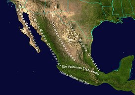
파자리토 산맥(시에라 파자리토스[2])은 시에라 마드레 옥시덴탈 산맥의 남쪽 끝에 있는 작은 산맥입니다.그들은 멕시코 서부의 나야리트 주에 위치해 있다.
지리
파자리토족은 서쪽은 화지믹의 [3]계곡, 동쪽은 카모틀란 [4]강의 계곡과 경계를 이루고 있다.레인지에는 경사진 블록이 서쪽에 절벽이 있고 동쪽에 경사가 완만한 [4]침식면이 있습니다.파자리토 산맥은 북쪽으로 아텐고 강, 남쪽으로 ENE-WSW 좌회전-횡단층, 산티아고 [5]강에 둘러싸여 있다.
지질학
파자리토 산맥은 신생대 관입 화강암과 화강암으로 이루어져 있으며, 주로 규소화산(23~14mo)과 규소화산(12~8mo)[5]이 덮고 있다.
주 및 참고 자료
- ^ Gómez-Reyes, Eugenio; et al. (2015). "Water balance of La Yesca municipality, Nayarit, México / El balance hídrico en el municipio de La Yesca, Nayarit, México" (PDF). Revista Bio Ciencias. 3 (3): 228–246. doi:10.15741/revbio.03.03.09.
- ^ 미국 국립지질정보국(National Geospace-Intelligence Agency), GEOnet Names Server의 Sierra Pazaritos(Unverified - D)
- ^ 미국 국립지질정보국 GEOnet Names Server의 Arroyo Huajimic(승인 - N)
- ^ a b Barrera R., Rosier Omar (2002). "Consideraciones geomorfologías sobre la Sierra Madre Occidental en el norte de Jalisco, México / Geomorphological considerations about the Sierra Madre Occidental in Northern Jalisco, México" (PDF). Investigaciones geográficas (48): 44–75, page 56. Archived (PDF) from the original on 1 September 2017.
- ^ a b Nieto-Samaniego, Ángel F.; et al. (1999). "Variation of Cenozoic extension and volcanism across the southern Sierra Madre Occidental volcanic province, Mexico" (PDF). Geological Society of America Bulletin. 111 (3): 347–363. doi:10.1130/0016-7606(1999)111<0347:VOCEAV>2.3.CO;2.


