모로토타운
Moroto Town모로토 | |
|---|---|
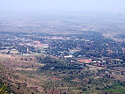
 모로토 타운 - 모로토 산에서 바라본 | |
| 좌표: 02°31′48″N 34°40′12″e / 2.53,000°N 34.67,000°E좌표: 02°31′48″N 34°40′12″E / 2.53000°N 34.67000/ 2. | |
| 나라 | |
| 지역 | 북부 주 |
| 하위 영역 | 카라모자 하위 지역 |
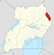
| 구 | 모로토 구 |
| 표고 | 4,490ft(1,480m) |
| 인구 (2020년 추정) | |
| • 합계 | 16,300[1] |
모로토는 우간다 북부 지방의 모로토 구에 있는 마을이다. 지구본부의 위치다.[2]
위치
모로토는 우간다 북부 지역에서 가장 큰 도시인 굴루에서 동쪽으로 약 316km(196mi)[3]이다. 이곳은 우간다 동부 지역에서 가장 큰 도시인 음발레의 북동쪽에 있는 도로로 약 271km(168mi)이다.[4]
모로토는 우간다의 수도이자 가장 큰 도시인 캄팔라 북동쪽, 도로로 약 528km(328mi)에 위치해 있다.[5] 모로토 타운의 지리적 좌표는 2°31'48.0"N, 34°40'12.0"E(위도:2)이다.5300; 경도:34.6700).[6] Moroto는 평균 해발 1,370미터(4,490피트)의 높이에 앉아있다.[7]
인구
2002년 전국 인구조사에서 모로토의 인구는 7,380명으로 추산되었다. 2010년 우간다 통계국(UBOS)은 인구가 11,600명으로 추정했다. 2011년 UBOS는 중간연도의 인구를 12,300명으로 추정했다.[8] 2014년 전국 인구조사에서 모로토 인구는 14,196명으로 집계되었다.[1]
2020년 UBOS는 이 마을의 중년의 인구를 16,300명으로 추산했다. 인구청은 2014~2020년 모로토 타운 인구가 연평균 2.39%씩 증가했다고 계산했다.[1]
운송
모로토 버스 정류장에서 우간다의 캄팔라, 소로티, 음발레, 나카피리피리트 등지로 가는 직행버스 서비스가 있다. 모로토로 가는 간선도로는 소로티모로토 도로로 2020년 1월 현재 완전히 포장되어 있다. 모로토-나카피리피리트 도로도 완전히 포장되어 있다.[9] 이 마을은 또한 시내에서 서쪽으로 약 8킬로미터(5 mi) 떨어진 곳에 위치한 공공 공항인 모로토 공항이 운행하고 있다.[10]
관심장소
The additional points of interest lie within the town limits or near the edges of town: (1) the offices of Moroto Town Council (2) Mount Moroto, rising to an elevation of 3,083 metres (10,115 ft) about 3 kilometres (1.9 mi) east of town (3) Moroto central market (4) a branch of the National Social Security Fund (5) Moroto Regional Referral Hospital우간다 보건부(6)백년은행 지점과 (7) 스탠빅은행 우간다유한공사 지점. (8) 다미아노 줄리오 구제티 주교가 이끄는 로마 가톨릭 교구 모로토 교구의 본부.[11]
참고 항목
참조
- ^ Jump up to: a b c Uganda Bureau of Statistics (14 June 2020). "The population of all Ugandan cities and towns with more than 15,000 inhabitants according to census results and latest official projections" (Citypopulation.de Quoting Uganda Bureau of Statistics). Citypopulation.de. Retrieved 28 January 2021.
- ^ Ssemutooke, Joseph (7 October 2017). "It's not all gloom in Karamoja". Daily Monitor. Kampala. Retrieved 9 August 2017.
- ^ Google (28 January 2021). "Road Distance Between Gulu, Uganda And Moroto, Uganda" (Map). Google Maps. Google. Retrieved 28 January 2021.
- ^ Google (28 January 2021). "Map Showing Mbale, Uganda And Moroto, Uganda With Route Marker" (Map). Google Maps. Google. Retrieved 28 January 2021.
- ^ Google (28 January 2021). "Road Distance Between Kampala, Uganda And Moroto, Uganda With Interactive Map" (Map). Google Maps. Google. Retrieved 28 January 2021.
- ^ Google (28 January 2021). "Location of Moroto Town, Northern Region, Uganda" (Map). Google Maps. Google. Retrieved 28 January 2021.
- ^ The Editors of Encyclopaedia Britannica (28 January 2021). "Profile of Moroto, Uganda". Chicago, Illinois, United States: Encyclopaedia Britannica. Retrieved 8 January 2021.
- ^ Uganda Burau of Statistics (2012). "Estimated Population of Moroto Town In 2002, 2010 And 2011" (PDF). Kampala: Uganda Bureau of Statistics. Retrieved 28 January 2021.
- ^ Daily Monitor (17 January 2020). "New Moroto-Soroti road boosts trade". Daily Monitor. Kampala. Retrieved 28 January 2021.
- ^ Google (28 January 2021). "Road Distance Between Moroto, Uganda And Moroto Airport, Uganda" (Map). Google Maps. Google. Retrieved 28 January 2021.
- ^ Steven Ariong and Esther Oluka (27 May 2014). "Moroto Diocese gets new bishop". Daily Monitor. Kampala. Retrieved 21 July 2015.


