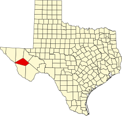
텍사스 제프 데이비스 카운티의 고속도로 목록
List of highways in Jeff Davis County, Texas다음은 텍사스 교통부가 관리하는 텍사스 주 제프 데이비스 카운티의 모든 주 고속도로 목록이다.텍사스의 모든 주 고속도로는 포장되어 있다.
인터스테이트
| 경로 이름 | 방향 | 터미 | 결합체 | 길이 | 언급 |
|---|---|---|---|---|---|
| W/E | 컬버슨 카운티로 리브스 군 | 7.0마일(11.3km)[2] |
미국의 고속도로
| 경로 이름 | 방향 | 터미 | 결합체 | 길이 | 언급 |
|---|---|---|---|---|---|
| W/E | 컬버슨 카운티로 프레시디오 군 | 26.0마일(41.8km)[2] |
주 고속도로
| 경로 이름 | 방향 | 터미 | 결합체 | 길이 | 언급 |
|---|---|---|---|---|---|
| S/N | Presidio County to 리브스 군 | 41.9마일(67.4km)[2] | |||
| S/N | 브루스터 카운티로 컬버슨 군 | 66.2마일 (1965km)[2] | |||
| W/E | 43.1마일(69.4km)[6] |
주 고속도로 루프 및 스퍼
| 경로 이름 | 방향 | 터미 | 결합체 | 길이 | 언급 |
|---|---|---|---|---|---|
| S/N | 데드 엔드 | 0.5마일(0.8km)[7] | 맥도널드 천문대 | ||
| S/N | 에 대한 막다른 골목 | 1.5마일(2.4km)[8] | 맥도널드 천문대 |
주립공원길
| 경로 이름 | 방향 | 터미 | 결합체 | 길이 | 언급 |
|---|---|---|---|---|---|
| W/E | 에 대한 막다른 골목 | 4.0마일(6.4km)[9] | 데이비스 산맥 주립공원 |
도로 마케팅을 위한 농장 및 목장
| 경로 이름 | 방향 | 터미 | 결합체 | 길이 | 언급 |
|---|---|---|---|---|---|
| W/E | 8.8마일(14.2km)[10] | ||||
| W/E | 에 대한 막다른 골목 | 10.9마일(17.5km)[11] | 버팔로 트레일즈 보이 스카우트 목장 | ||
| W/E | 에 대한 막다른 골목 | 3.5km(3.4마일)[12] | 미트레 피크 걸스카우트 캠프 | ||
| W/E | 컬버슨 카운티로 | 5.3마일(8.5km)[2] | |||
| W/E | 리브스 군 ~ 리브스 군 | 4.7마일(7.6km)[2] |
역사길
| 경로 이름 | 방향 | 터미 | 언급 |
|---|---|---|---|
| W/E | 컬버슨 카운티로 리브스 군 | 1991년 I-10으로 대체 | |
| W/E | 리브스 군 ~ 리브스 군 | 1992년 FM 3078로 대체 | |
| W/E | 컬버슨 카운티로 리브스 군 | 1939년 US 80으로 대체 | |
| W/E | 컬버슨 카운티로 프레시디오 군 | 1939년 US 90으로 대체됨 | |
| W/E | 리브스 군 ~ 리브스 군 | 1935년까지 SH 196으로 대체됨 | |
| W/E | 리브스 군 ~ 리브스 군 | 1939년 US 290으로 대체 | |
| W/E | 브루스터 카운티로 컬버슨 군 | 1939년 SH 118로 대체 |
인접 국가 및 카운티
참조
- ^ Transportation Planning and Programming Division (n.d.). "Interstate Highway No. 10". Highway Designation Files. Texas Department of Transportation. Retrieved 2009-09-27.
- ^ a b c d e f 텍사스 교통부, 지도 측정 유틸리티를 이용한 주 전체 계획 지도
- ^ Transportation Planning and Programming Division (n.d.). "U.S. Highway No. 90". Highway Designation Files. Texas Department of Transportation. Retrieved 2009-09-27.
- ^ Transportation Planning and Programming Division (n.d.). "State Highway No. 17". Highway Designation Files. Texas Department of Transportation. Retrieved 2009-09-27.
- ^ Transportation Planning and Programming Division (n.d.). "State Highway No. 118". Highway Designation Files. Texas Department of Transportation. Retrieved 2009-09-27.
- ^ a b Transportation Planning and Programming Division (n.d.). "State Highway No. 166". Highway Designation Files. Texas Department of Transportation. Retrieved 2009-09-27.
- ^ a b Transportation Planning and Programming Division (n.d.). "State Highway Spur No. 77". Highway Designation Files. Texas Department of Transportation. Retrieved 2009-09-27.
- ^ a b Transportation Planning and Programming Division (n.d.). "State Highway Spur No. 78". Highway Designation Files. Texas Department of Transportation. Retrieved 2009-09-27.
- ^ a b Transportation Planning and Programming Division (n.d.). "Park Road No. 3". Highway Designation Files. Texas Department of Transportation. Retrieved 2009-09-27.
- ^ a b Transportation Planning and Programming Division (n.d.). "Ranch to Market Road No. 505". Highway Designation Files. Texas Department of Transportation. Retrieved 2009-09-27.
- ^ a b Transportation Planning and Programming Division (n.d.). "Ranch to Market Road No. 1832". Highway Designation Files. Texas Department of Transportation. Retrieved 2009-09-27.
- ^ a b Transportation Planning and Programming Division (n.d.). "Ranch to Market Road No. 1837". Highway Designation Files. Texas Department of Transportation. Retrieved 2009-09-27.
- ^ Transportation Planning and Programming Division (n.d.). "Farm to Market Road No. 2017". Highway Designation Files. Texas Department of Transportation. Retrieved 2009-09-27.
- ^ Transportation Planning and Programming Division (n.d.). "Farm to Market Road No. 3078". Highway Designation Files. Texas Department of Transportation. Retrieved 2009-09-27.
- ^ Transportation Planning and Programming Division (n.d.). "U.S. Highway No. 80". Highway Designation Files. Texas Department of Transportation. Retrieved 2009-09-27.
- ^ Transportation Planning and Programming Division (n.d.). "U.S. Highway No. 290". Highway Designation Files. Texas Department of Transportation. Retrieved 2009-09-27.
- ^ Transportation Planning and Programming Division (n.d.). "State Highway No. 1". Highway Designation Files. Texas Department of Transportation. Retrieved 2009-09-27.
- ^ Transportation Planning and Programming Division (n.d.). "State Highway No. 3". Highway Designation Files. Texas Department of Transportation. Retrieved 2009-09-27.
- ^ Transportation Planning and Programming Division (n.d.). "State Highway No. 27". Highway Designation Files. Texas Department of Transportation. Retrieved 2009-09-27.
- ^ Transportation Planning and Programming Division (n.d.). "State Highway No. 196". Highway Designation Files. Texas Department of Transportation. Retrieved 2009-09-27.
- ^ Transportation Planning and Programming Division (n.d.). "State Highway No. 233". Highway Designation Files. Texas Department of Transportation. Retrieved 2009-09-27.


