라르쇠야
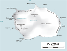
Larsøya라르쇠야([1][2][3][4]Larsøya)는 남대서양 부베테예야 섬의 남서쪽 끝자락에 위치한 길이 0.2해리(0.4km)도 안 되는 바위섬이다. 그것은 칼 천 휘하의 독일 탐험대에 의해 1898년에 대략적으로 도표화되었다. 하랄드 혼트베트 선장 휘하의 노르웨이 원정대는 1927년 12월 노르베지아 선박에서 섬에 상륙해 원정대의 후원자인 라르스 크리스텐센의 이름을 땄다.[5]
참고 항목
참조
- ^ "Larsøya". Norwegian Polar Institute. Archived from the original on 10 May 2012. Retrieved 8 May 2012.
- ^ Barr, Susan (1987). Norway's Polar Territories. Oslo: Aschehoug. p. 59. ISBN 82-03-15689-4.
- ^ P. E. Baker (1967). "Historical and Geological Notes on Bouvetøya" (PDF). British Antarctic Survey Bulletin (13): 71–84. Archived from the original (PDF) on 8 May 2012. Retrieved 8 May 2012.
- ^ Rubin, Jeff (2005). Antarctica. Lonely Planet. p. 155. ISBN 1-74059-094-5.
- ^ "Lars Island". Geographic Names Information System. United States Geological Survey. Retrieved 2013-06-03.
좌표: 54°27′11″S 3°18′54″E / 54.45306°S 3.31500°E
![]() 이 문서에는 미국 지질조사국(Geographic Names Information System)의 공용 도메인 자료가 통합되어 있다.
이 문서에는 미국 지질조사국(Geographic Names Information System)의 공용 도메인 자료가 통합되어 있다.


