키란츠, 아르메니아
Kirants, Armenia좌표:41°03′01″N 45°06′05″E/41.05028°N 45.10139°E
키란츠 Կիրանց | |
|---|---|
 키란트의 경치 | |
 키란츠 | |
| 좌표: 41°03′01″N 45°06′05″E / 41.05028°N 45.10139°E | |
| 나라 | |
| 주 | 타부시 |
| 인구 | |
| • 합계 | 352 |
| 시간대 | UTC+4(AMT) |
| 키란트, 아르메니아 GEOnet Names Server | |
키란트(Armenian: կիանց)는 아르메니아 타부시 성의 마을이다.8세기 키란트 수도원, 13세기 아라켈롯 수도원이 키란트 인근에 위치해 있다.
토포니미
이 마을은 1967년까지 게타센으로 알려져 있었다.
갤러리
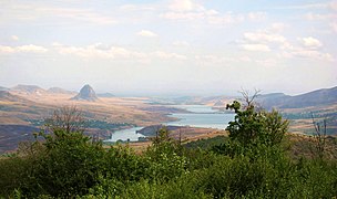
키란트 주변의 풍경

스라노츠시 다리
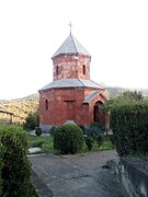
성 아스트바틴 교회
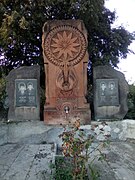
아르타흐 전쟁 기념비

키란츠 수도원 인테리어
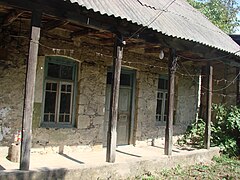
키란트의 옛집
.jpg)


.jpg)

참조
외부 링크
| 위키미디어 커먼즈에는 키란트와 관련된 미디어가 있다. |
- 아르메니아 통계위원회 2001년 아르메니아 인구조사 결과 보고서
- 브래디 키슬링, 아르메니아 재발견 페이지 116; 원본은 Archive.org에 보관되어 있고 현재 버전은 Armeniapedia.org에 있다.
자본: 이제반 | ||
| 어반 공동체 |  | |
| 농촌 공동체 | ||
| 비커뮤니티 정착지 | ||
| 버려진 정착지 | ||


