메릴랜드 켄트 포트
Kent Fort, Maryland| 켄트 포트 | |
|---|---|
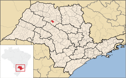
 메릴랜드 내 위치  메릴랜드 켄트 포트(미국) | |
| 일반 정보 | |
| 읍 또는 시 | 메릴랜드 켄트 섬 |
| 나라 | |
| 좌표 | 38°50°N 76°22°W/38.84°N 76.37°W |
| 완료된 | 1631 |
Kent Fort was a fort and settlement located near 38°50′N 76°22′W / 38.84°N 76.37°WCoordinates: 38°50′N 76°22′W / 38.84°N 76.37°W on southern Kent Island in colonial Virginia and later Maryland, and was the first English settlement within the boundaries of present-day Maryland and the fourth oldest permanent English s미국 내에서는 버지니아주 제임스타운(1607), 버지니아주 햄튼(1609–10), 매사추세츠주 플리머스(1620)에 이어 세 번째다.[1][2]이 요새는 1631년 윌리엄 클라이보른에 의해 세워졌으며, 초기 켄트 섬의 중심부였다.그러나 세기가 끝날 무렵에는 활동이 북쪽의 브로드 크릭 항구도시로 옮겨갔다.
오늘날 한때 요새가 서 있던 땅이 동부만으로 침식되어, 정착의 유일한 흔적은 이 만의 잘 알려진 기지들이다.정착지가 있던 곳에 석자 표시가 되어 있으며, 켄트 포트 마노르 역시 켄트 포트 정착지가 있던 자리에 위치하고 있다.[3]
이 식민지는 이스턴 만에 현재의 두 교각과 켄트 포트 로드 아래쪽에 위치해 있었다.3개의 나무로 된 우물이 해안에서 약 75피트 떨어진 곳에 위치해 있었고 그 근처에서 다른 유물들이 발견되었다.주목할 만한 것은 1631년의 다른 유적지에서 나온 파란색 인도 무역 구슬이었다.또한 1631년 10월 17일 불에 탄 창고에서 불이 났을 가능성이 있는 녹은 구슬도 발견되었다.
참조
- ^ "Archived copy". Archived from the original on 2016-06-02. Retrieved 2009-11-28.
{{cite web}}: CS1 maint: 타이틀로 보관된 사본(링크) - ^ Smardz, Zofia (2007-07-11). "Somewhere Over the Bay Bridge". The Washington Post. Retrieved 2013-03-09.
- ^ "Archived copy". Archived from the original on 2008-06-02. Retrieved 2008-05-16.
{{cite web}}: CS1 maint: 타이틀로 보관된 사본(링크)