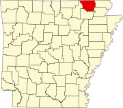
아칸소 주 랜돌프 카운티 잭슨 타운쉽
Jackson Township, Randolph County, Arkansas잭슨 타운쉽 | |
|---|---|
| 좌표:36°25′03″N 91°05′13″w/36.417455°N 91.086920°W좌표: 36°25′03″N 91°05′13″W / 36.417455°N 91.086920°W/ [1] | |
| 나라 | 미국 |
| 주 | 아칸소 주 |
| 카운티 | 랜돌프 |
| 면적 | |
| • 합계 | 17.728 제곱미(45.92km2) |
| • 육지 | 17.669 sq mi(45.76km2) |
| • 물 | 0.059 sqmi(0.15km2) |
| 표고 | 479 ft (107 m) |
| 인구 | |
| • 합계 | 241 |
| • 밀도 | 14/sq mi(5.2/km2) |
| 시간대 | UTC-6(CST) |
| • 여름(DST) | UTC-5(CDT) |
| FIPS 코드[2][3] | 05-91878 |
| GNIS ID[2][3] | 69026 |
잭슨 타운쉽은 미국 아칸소 주 랜돌프 카운티의 읍이다.[4]2010년 미국 인구 조사 기준 총 인구는 241명으로 2000년 269명보다 10.41% 감소했다.[1][5][6][7]
2010년 인구조사에 따르면 잭슨 타운쉽은 36°25′03″N 91°05′13″W / 36.417455°N 91.086920°W/ (36.417455, -91.086920)에 위치한다.[1]총 면적은 17.728제곱마일(45.92제곱km)이며, 이 중 17.669제곱미(45.76km2)는 육지, 0.059제곱미(0.15km2)는 물(0.33%)[1]이다.USGS 국가 고도 데이터 집합에 따르면, 고도는 479피트(146m)이다.[2]
참조
- ^ a b c d e f "County Subdivisions (2010): Arkansas". 2010 Census Gazetteer Files. United States Census Bureau. Archived from the original (TXT) on May 31, 2014. Retrieved May 31, 2014.
- ^ a b c d "Feature ID 69026: Township of Jackson (Randolph County, Arkansas)". Geographic Names Information System. United States Geological Survey. Retrieved May 31, 2014.
- ^ a b "FIPS55 Data: Arkansas". FIPS55 Data. United States Geological Survey. February 23, 2006. Archived from the original (TXT) on June 18, 2006. Retrieved May 31, 2014.
- ^ "Summary Population and Housing Characteristics, CPH-1-5, Arkansas" (PDF). 2010 Census of Population and Housing. United States Census Bureau. September 2012. Retrieved May 31, 2014.
- ^ "2010 Demographic Profile (DP-1): Jackson township, Randolph County, Arkansas". American FactFinder. United States Census Bureau. Archived from the original on February 12, 2020. Retrieved May 31, 2014.
- ^ "2000 Demographic Profile (DP-1): Jackson township, Randolph County, Arkansas". American FactFinder. United States Census Bureau. Archived from the original on February 12, 2020. Retrieved May 31, 2014.
- ^ "County Subdivisions (2000)". 2000 Census Gazetteer Files. United States Census Bureau. Archived from the original (Zipped TXT) on May 31, 2014. Retrieved May 31, 2014.
외부 링크
- "2010 Census Block Map: Jackson Township, Arkansas" (PDF). Arkansas 2010 Census Block Maps - County Subdivisions. U.S. Census Bureau.
- "2013 Boundary and Annexation Survey (BAS) Map: Randolph County, Arkansas" (PDF). Boundary and Annexation Survey (BAS) Shapefiles and Maps. U.S. Census Bureau.
- "2010 Census County Subdivision Maps: Arkansas" (PDF). County Subdivision Maps. U.S. Census Bureau.


