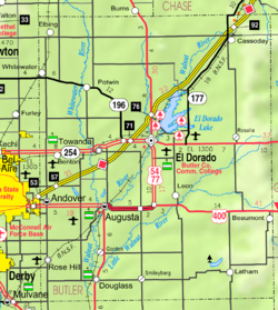
캔자스 주 고든
Gordon, Kansas캔자스 주 고든 | |
|---|---|
 | |
| 좌표:37°35′19″n 96°59′26″w/37.58861°N 96.99056°W좌표: 37°35′19″N 96°59′26″W / 37.58861°N 96.99056°W | |
| 나라 | 미국 |
| 주 | 캔자스. |
| 카운티 | 버틀러 |
| 표고 | 1,217ft(371m) |
| 시간대 | UTC-6(CST) |
| • 여름(DST) | UTC-5(CDT) |
| GNIS ID | 475032 [1] |
고든은 미국 캔자스 주 버틀러 카운티에 있는 비법인 공동체다.[1]
역사
1884년 6월 30일부터 1936년 6월 30일까지 고든에 우체국이 있었다.[2]
고든은 애치슨, 토페카, 산타페 철도의 역이었다.[3]
교육
이 커뮤니티는 오거스타 USD 402 공립학교 구역에서 서비스된다.
저명인사
참조
- ^ a b "Gordon, Kansas". Geographic Names Information System. United States Geological Survey.
- ^ "Kansas Post Offices, 1828-1961 (archived)". Kansas Historical Society. Archived from the original on 9 October 2013. Retrieved 5 June 2014.
- ^ Blackmar, Frank Wilson (1912). Kansas: A Cyclopedia of State History, Embracing Events, Institutions, Industries, Counties, Cities, Towns, Prominent Persons, Etc. Standard Publishing Company. pp. 765.
- ^ 미네소타 역사학회 로잘리 왈 정의의 인명 스케치
추가 읽기
외부 링크


