가스트
Gaast가스트 | |
|---|---|
마을 | |
 가스트 | |
 깃발  국장 | |
 옛 완세라디엘 시의 위치 | |
 가스트 네덜란드의 위치  가스트 가스트(네덜란드) | |
| 좌표:좌표: 53°0′59″N 5°24′30″E / 53.01639°N 5.40833°E/ 5 | |
| 나라 | |
| 주 | |
| 시 | |
| 면적 | |
| • 합계 | 5.69km2(2.20제곱 mi) |
| 표고 | 1.0m(3.3ft) |
| 인구 (2021)[1] | |
| • 합계 | 200 |
| • 밀도 | 35/km2(91/sq mi) |
| 우편번호 | 8757[1] |
| 다이얼링 코드 | 0515 |
가스트는 네덜란드 프리슬란트 주에 있는 수드웨스트 프리슬란 시의 마을이다.2017년 1월 인구는 220명 안팎이었다.[3]
역사
이 마을은 13세기에 루테카가스트로 처음 언급되었으며, '게스트(높은 모래땅)'[4]라는 뜻이다.가스트는 구 주이더제 근처의 모래 언덕에서 개발되었다(요즘은:IJselmeer).[5]바다와 가까워서 문제가 생겼다.1643년, 다이크가 부서졌다.1702년, 가까스로 버텨냈지만, 해안에서 떨어진 23척의 배가 가스트 근처에서 침몰했다.경제는 어업과 항해에 기반을 두었으나 농업 공동체가 되었다.[6]
네덜란드 리폼 교회는 14세기에 세워졌으며, 1916년에 복원되었다.[5][6]
가스트는 1840년에 217명의 사람들의 고향이었다.[7]2011년 이전에, 이 마을은 완세라디엘 시의 일부였다.[7]
갤러리

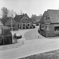
가스트의 교회

가스트의 거리

운하 전망
둑에서 보기(1979)


_(26639597799).jpg)

참조
- ^ a b c "Kerncijfers wijken en buurten 2021". Central Bureau of Statistics. Retrieved 5 April 2022.
two entries
- ^ "Postcodetool for 8757JP". Actueel Hoogtebestand Nederland (in Dutch). Het Waterschapshuis. Retrieved 5 April 2022.
- ^ Kerncijpers Wijken 2017 - CBS Statline
- ^ "Gaast - (geografische naam)". Etymologiebank (in Dutch). Retrieved 5 April 2022.
- ^ a b Ronald Stenvert & Sabine Broekhoven (2000). "Gaast" (in Dutch). Zwolle: Waanders. ISBN 90 400 9476 4. Retrieved 4 April 2022.
- ^ a b "Gaast". Friesland Wonderland (in Dutch). Retrieved 5 April 2022.
- ^ a b "Gaast". Plaatsengids (in Dutch). Retrieved 5 April 2022.
외부 링크
![]() Wikimedia Commons의 Gaast 관련 미디어
Wikimedia Commons의 Gaast 관련 미디어