미네소타 주 더프리스
Dumfries, Minnesota덤프리스 | |
|---|---|
| 좌표:44°20′42″n 92°07′13″w/44.34500°N 92.12028°W좌표: 44°20′42″N 92°07′13″W / 44.34500°N 92.12028W/ | |
| 나라 | 미국 |
| 주 | 미네소타 |
| 카운티 | 와바샤 현 |
| 타운쉽 | 글래스고 타운쉽 |
| 표고 | 791ft(241m) |
| 시간대 | UTC-6(중앙(CST)) |
| • 여름(DST) | UTC-5(CDT) |
| 우편번호 | 55981 |
| 지역 번호 | 651년과 507년 |
| GNIS 피쳐 ID | 654682[1] |
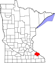
덤프리스(Dumfries)는 미국 미네소타 주 와바샤 카운티 글래스고 타운쉽에 있는 비법인 공동체다.
지리
이 공동체는 주 고속도로 60(MN 60)을 따라 와바샤와 줌브로 폭포 사이에 위치해 있다.와바샤 군 도로 20번, 30번, 86번도 바로 그 지역에 있다.트라웃 브룩과 줌브로 강은 덤프리스 근처에서 만난다.그 밖의 인근 지역으로는 와바샤, 웨스트 알바니, 테일만, 켈로그, 줌브로 폭포 등이 있다.
역사
더프리스라는 우체국은 1894년에 설립되어 1912년까지 계속 운영되었다.[2]그 공동체는 스코틀랜드의 덤프리의 이름을 따서 명명되었다.[3]
참조
- ^ "Dumfries, Minnesota". Geographic Names Information System. United States Geological Survey.
- ^ "Wabasha County". Jim Forte Postal History. Retrieved 10 August 2015.
- ^ Upham, Warren (1920). Minnesota Geographic Names: Their Origin and Historic Significance. Minnesota Historical Society. p. 556.


