인디애나 주 콜몬트
Coalmont, Indiana인디애나 주 콜몬트 | |
|---|---|
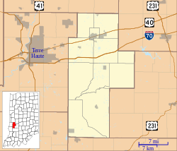
 인디애나 주 클레이 카운티에 있는 콜몬트의 위치. | |
| 좌표:39°11′36″N 87°13′52″w/39.1933°N 87.23111°W좌표: 39°11′36″N 87°13′52″W / 39.19333°N 87.23111°W / | |
| 나라 | 미국 |
| 주 | 인디애나 주 |
| 카운티 | 점토 |
| 타운쉽 | 루이스 |
| 면적 | |
| • 합계 | 1.5 sq mi(3.9 km2) |
| • 육지 | 1.5 sq mi(3.9 km2) |
| • 물 | 0 sq mi(0km2) |
| 표고 | 630ft (103m) |
| 인구 (2010) | |
| • 합계 | 402 |
| • 밀도 | 268/sq mi (1968.4/km2) |
| 우편번호 | 47438 |
| FIPS 코드 | 18-14032[1] |
| GNIS 피쳐 ID | 432712[2] |
콜몬트는 미국 인디애나 주 클레이 카운티 루이스 타운쉽에 있는 비법인 공동체 및 인구조사 지정지다.Terre Haute Metropolitan Statistical Area의 일부다.2010년 인구조사를 기준으로 인구는 402명이다.[3]
역사
콜몬트에 우체국이 1901년에 설립되었다.[4]그 지역에 석탄이 매장되어 있어서 이름을 고르게 되었다.[5]
지리
콜몬트는 클레이 카운티 남서쪽 39°11′36″N 87°13′52″W / 39.1933°N 87.23111°W/ 에 위치한다.그것의 서쪽 경계선은 설리번 군선이다.인디애나 주 도로 159는 공동체의 중심을 통해 남북으로 뻗어 있으며, IN 48은 CDP의 남쪽 가장자리를 형성하고 있다.샤카막 주립 공원은 바로 남쪽이다.제이슨빌은 159번과 48번 노선에서 남동쪽으로 3.4마일(5.5km), 하이메라는 48번 IN에서 서쪽으로 4마일(6km)이다.
인구통계학
| 역사인구 | |||
|---|---|---|---|
| 인구조사 | Pop. | %± | |
| 미국 십수년 인구[6] 조사 | |||
참조
- ^ "U.S. Census website". United States Census Bureau. Retrieved 2008-01-31.
- ^ "Coalmont, Indiana". Geographic Names Information System. United States Geological Survey. Retrieved 2009-10-10.
- ^ "Geographic Identifiers: 2010 Demographic Profile Data (G001): Coalmont CDP, Indiana". U.S. Census Bureau, American Factfinder. Archived from the original on February 12, 2020. Retrieved August 4, 2014.
- ^ "Clay County". Jim Forte Postal History. Retrieved 30 August 2014.
- ^ Baker, Ronald L. (October 1995). From Needmore to Prosperity: Hoosier Place Names in Folklore and History. Indiana University Press. p. 99. ISBN 978-0-253-32866-3.
...and named for the coal here...
- ^ "Census of Population and Housing". Census.gov. Retrieved June 4, 2016.


