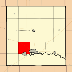
캔자스 주 바톤 카운티 버팔로 타운쉽
Buffalo Township, Barton County, Kansas버팔로 타운쉽 | |
|---|---|
 바톤 카운티의 위치 | |
| 좌표:38°23′27″N 098°52′00″w/38.39083°N 98.86667°W좌표: 38°23′27″N 098°52′00″W / 38.39083°N 98.86667°W/ | |
| 나라 | 미국 |
| 주 | 캔자스. |
| 카운티 | 바톤 |
| 면적 | |
| • 합계 | 34.14 sq mi(88.41km2) |
| • 육지 | 34.09 sq mi(88.3km2) |
| • 물 | 0.04 sq mi(0.11km2) 0.12% |
| 표고 | 1,877ft(572m) |
| 인구 (2010) | |
| • 합계 | 417 |
| • 밀도 | 12/sq mi(4.7/km2) |
| GNIS 피쳐 ID | 0475639 |
버팔로 타운쉽은 미국 캔자스 주 바톤 카운티에 있는 타운쉽으로 2010년 인구조사 기준 인구는 417명이다.[1]
버팔로 타운쉽은 1872년에 조직되었다.[2]
지리
버팔로 타운쉽은 34.14 평방 마일(88.4km2)의 면적에 걸쳐 있으며, 그레이트 벤드 시는 남동쪽 경계선에 있지만, 통합된 정착지는 포함되어 있지 않다.USGS에 따르면, 이 곳에는 에버렛이라는 한 묘지가 있다.
참조
- ^ "Profile of General Population and Housing Characteristics: 2010 Demographic Profile Data (DP-1): Buffalo township, Barton County, Kansas". United States Census Bureau. Retrieved July 12, 2012.
- ^ History of the State of Kansas: Containing a Full Account of Its Growth from an Uninhabited Territory to a Wealthy and Important State. A. T. Andreas. 1883. p. 762.
외부 링크


