아팍
Apac아팍 | |
|---|---|
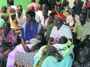
 아팍 병원 환자 | |
| 좌표:01°59′06″N 32°32′06″E/1.98500°N 32.53500°E좌표: 01°59′06″N 32°32′06″E / 1.98500°N 32.53500°E | |
| 나라 | |
| 지역 | 우간다 북부 |
| 하위 영역 | 랑고 하위 지역 |
| 구 | 아팍 구 |
| 정부 | |
| • 시장 | 지미 오켈로 (2016년)[1] |
| 표고 | 3,540ft(1,080m) |
| 인구 (2020년 추정) | |
| • 합계 | 67,700 |
| 웹사이트 | 홈 페이지 |
아팍(apac)은 우간다 북부 지역의 아팍 구에 있는 마을이다.구의 '치프타운'으로 구청 본부가 위치해 있다.그 지역은 그 도시의 이름을 따서 명명되었다.[1]
위치
아팍은 북부 우간다에서 가장 큰 도시인 굴루에서 남쪽으로 약 118km(73mi) 지점에 위치해 있다.[2]이 위치는 랑고 하위 지역에서 가장 큰 도시인 리라에서 남서쪽으로 약 62km(39mi) 지점에 위치해 있다.[3]마을의 좌표는:1°59'06.0"N, 32°32'06.0"E(위도:1)이다.9850; 경도:32.5350).[4]아팍 시 의회는 평균 해발 3,540피트(1,079m)의 고도에 위치해 있다.[5]
인구
2002년 전국 인구조사에서 그 도시의 인구는 약 10,140명으로 추산되었다.2010년 우간다 통계국(UBOS)에 의해 아팍의 인구는 약 13,300명으로 추산되었다.2011년 UBOS는 아팩의 중간인구를 약 13,700명으로 추산했다.[6]
2014년 8월, 전국 인구조사에서 아팍의 인구는 14,972명이다.2020년 인구청은 아팍 시의 중간인구를 6만6700명으로 추산했다.[7]
| 연도 | Pop. | ±% |
|---|---|---|
| 1969 | 378 | — |
| 1980 | 1,716 | +354.0% |
| 1991 | 5,783 | +237.0% |
| 2002 | 10,137 | +75.3% |
| 2010 | 13,300 | +31.2% |
| 2011 | 13,700 | +3.0% |
| 2014 | 14,972 | +9.3% |
| 2020 | 67,700 | +352.2% |
| 출처:[6][7] | ||
지역
관심장소
그 도시나 마을 한계 근처에 관심이 다음과 같은 내용을 거짓말:[4](를)아파크 구 행정부의 본부 아파크 시 의회의 아파크 종합 병원,120-bed 공공 병원,(c)사무실은 우간다 보건부(d)Alenga 초등 학교에 교외에 있는 공립 초등 학교에 의해 통치(b).(e) 일일 신선 농산물의 원천인 아팍 센트럴 마켓(Apac Central Market)과 (f) Rwekunye-Apac-Aduku-Lira-Kitgum-Musingo Road는 일반적인 서쪽에서 동쪽으로 마을을 통과한다.[8]
저명인사
- 밀턴 오보테 전 대통령 겸 국무총리
참고 항목
참조
- ^ a b Frank Oyugi (1 July 2016). "Excitement as Apac Municipality Becomes Operational". Uganda Radio Network. Kampala, Uganda. Retrieved 23 July 2021.
- ^ Google (31 December 2020). "Road Distance Between Gulu, Uganda And Apac, Uganda" (Map). Google Maps. Google. Retrieved 31 December 2020.
- ^ Google (31 December 2020). "Road Distance Between Apac And Lira In Uganda" (Map). Google Maps. Google. Retrieved 31 December 2020.
- ^ a b Google (2 July 2015). "Location of Apac, Northern Region, Uganda" (Map). Google Maps. Google. Retrieved 2 July 2015.
- ^ Apac Municipal Council (2016). "Elevation of Apac Municipality, Uganda". Apac Municipal Council. Apac, Uganda. Retrieved 23 July 2021.
- ^ a b Uganda Bureau of Statistics (2012). "Estimated Population of Apac In 2002, 2010 And 2011" (PDF). Uganda Bureau of Statistics. Kampala, Uganda. Archived from the original (Archived from the original on 7 July 2014) on 7 July 2014. Retrieved 23 July 2021.
- ^ a b Uganda Bureau of Statistics (14 June 2020). "The population of all Ugandan cities and towns with more than 15,000 inhabitants according to census results and latest official projections". Citypopulation.de Quoting Uganda Bureau of Statistics. Retrieved 23 July 2021.
- ^ Google (23 July 2021). "Map of Apac Municipality Showing Rwekunye–Apac–Aduku–Lira–Kitgum–Musingo Road Going Through The Middle of Town" (Map). Google Maps. Google. Retrieved 23 July 2021.


