애드마스턴/브롬리
Admaston/Bromley애드마스턴/브롬리 | |
|---|---|
| 아드마스턴/브롬리 타운십 | |
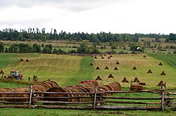
 Douglas 근처의 전형적인 시골 지역 | |
| 좌표:45°31°45°N 76°53′49§ W/45.52917°N 76.89694°W좌표: 45°31°45°N 76°5 ″ 49 w 45 / . 52917 ° N 76 . 89694 °W、 . 52917 - 76 . [1] | |
| 나라 | |
| 지방 | |
| 자치주 | 렌프루 |
| 형성된 | 2000년 1월 1일( |
| 정부 | |
| • 종류 | 타운십 |
| • 시장 | 마이클 도노휴 |
| • MP | Cheryl Gallant (CPC) |
| • MPP | 존 야카부스키(OPC) |
| 지역 | |
| • 토지 | 524.06km2(140.34평방마일) |
| 인구. (2016년)[2] | |
| • 합계 | 2,935 |
| • 밀도 | 5.6/km2(15/150mi) |
| 시간대 | UTC-5(EST) |
| • 여름 (DST) | UTC-4(EDT) |
| 우편번호 | K0J |
| 지역 번호 | 613,343 |
| 웹 사이트 | www |
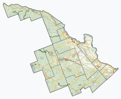
Admaston/Bromley는 캐나다 [1]온타리오주 동부 렌프루 카운티에 있는 도시입니다.2000년 1월 1일 아드마스턴과 브롬리 타운십이 합병되면서 설립되었습니다.그것은 작은 영국 [3]마을인 스태퍼드셔의 아드마스턴에서 이름의 일부를 따왔다.
커뮤니티
타운십은 Admaston, Balsam Hill, Belangers Corners, Bromley, Bulgers Corners, Connaught, Douglas, Perguslea, Fremo Corners, Kellys Corners, Martins Corners, McDougall, Mount Patrick, Oscroot, Occroote, Occroote, Occroote의 커뮤니티로 구성되어 있습니다.
더글러스 마을은 보네체르 강을 따라 있는 5개의 슛(물폭포) 중 세 번째입니다.다른 사람들은 캐슬포드, 렌프루, 포스 슈트, 에간빌이다.
인구 통계
| 연도 | Pop. | ±% |
|---|---|---|
| 1991 | 2,752[a] | — |
| 1996 | 2,837[b] | +3.1% |
| 2001 | 2,824 | −0.5% |
| 2006 | 2,716 | −3.8% |
| 2011 | 2,844 | +4.7% |
| 2016 | 2,935 | +3.2% |
| 2016년[5],[4] 2011년[6], 2006년 이전[7] | ||
캐나다 통계청이 실시한 2021년 인구조사에서 Admaston/Bromley의 인구는 1,305개의 총 민간 주거지 중 1,136개에 2,995명으로 2016년 인구 2,935명보다 2% 증가했다.519.59 km2(200.61 sq mi)의 대지 면적과 [8]함께 2021년 인구 밀도는 5.8/km2(14.9/sq mi)였다.
「 」를 참조해 주세요.
메모들
레퍼런스
- ^ a b "Admaston/Bromley". Geographical Names Data Base. Natural Resources Canada. Retrieved 2012-10-06.
- ^ a b "Admaston/Bromley census profile". 2011 Census of Population. Statistics Canada. Retrieved 2012-02-09.
- ^ The Citizen's District Staff of Correspondents (30 October 1937). "Origin of Place Names in District: Admaston". The Ottawa Evening Citizen. No. 115. Ottawa, Canada. p. 19. Retrieved 16 August 2015.
Admaston in Renfrew county was named after a village in Staffordshire, England.
- ^ "Census Profile, 2016 Census Admaston/Bromley, Township". Statistics Canada. Retrieved June 3, 2019.
- ^ "2011 Community Profiles". 2011 Canadian Census. Statistics Canada. March 21, 2019.
- ^ "2006 Community Profiles". 2006 Canadian Census. Statistics Canada. August 20, 2019.
- ^ "2001 Community Profiles". 2001 Canadian Census. Statistics Canada. July 18, 2021.
- ^ "Population and dwelling counts: Canada, provinces and territories, census divisions and census subdivisions (municipalities), Ontario". Statistics Canada. February 9, 2022. Retrieved April 2, 2022.
외부 링크


