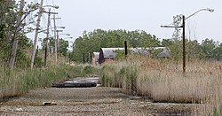
아디힐로
Addi Hilo| 아디힐로 | |
|---|---|
 | |
| 좌표 | 13°26′34″N 39°34′00″E / 13.44277616°N 39.56654435°E좌표: 13°26′34″N 39°34′00″E / 13.44277616°N 39.56654435E / |
| 유형 | 담수 인공호수 |
| 분지 국가 | 에티오피아 |
| 표면적 | 0.025km2(0.0097 sq mi) |
| 수량 | 03.16806×10⁶ m(88.12Acre⋅ft) |
| 지표면 표고 | 2,320m(7,580ft) |
| 정착지 | 콰하 |
아디 힐로는 에티오피아 티그레이 지역의 인데라 우레다에 위치한 저수지다. 저수지를 지탱하고 있는 토성댐은 1998년 SAERT에 의해 건설되었다.[1]
댐특성
- 댐 높이: 11.4m
- 댐 파고 길이: 171m
- 스필웨이 폭: 1미터
역량
- 원래 용량: 108 806 m³
- 데드 스토리지: 4328m³
- 저장 영역: 2.5 ha
2002년 저수지 기대수명(침전물이 채워지기 전 기간)은 9년으로 추정됐다.[1]
관개
- 설계 관개 구역: 9 ha
- 2002년 실제 관개 면적: 9 ha
환경
저수지의 유역은 0.72km²로 둘레는 3.34km, 길이는 1210m이다. 저수지는 급속한 침하로 고생하고 있다.[2] 유역의 석판학은 주로 아굴라 셰일과 작은 메켈레 돌레라이트다.[1] 관개를 위해 사용될 수 있는 물의 일부는 침수로 인해 손실된다; 긍정적인 부작용은 이것이 지하수 재충전에 기여한다는 것이다.[3]
참조
- ^ a b c De Wit, Joke (2003). Stuwmeren in Tigray (Noord-Ethiopië): kenmerken, sedimentatie en sediment-bronnen. Unpub. M.Sc. thesis. Department of Geography, K.U.Leuven.
- ^ Nigussie Haregeweyn, and colleagues (2006). "Reservoirs in Tigray: characteristics and sediment deposition problems". Land Degradation and Development. 17: 211–230. doi:10.1002/ldr.698.
- ^ Nigussie Haregeweyn, and colleagues (2008). "Sediment yield variability in Northern Ethiopia: A quantitative analysis of its controlling factors". Catena. 75: 65–76. doi:10.1016/j.catena.2008.04.011.


