매사추세츠 홀리요크 록밸리
Rock Valley, Holyoke, Massachusetts록밸리 | |
|---|---|
 록밸리길 가로경관 | |
| 좌표:42°11′38.33″N 72°40′33.화씨 33도/42.1939806°N 72.6759250°W좌표: 42°11′38.33″N 72°40′33.33″W / 42.1939806°N 72.6759250°W/ | |
| 나라 | 미국 |
| 주 | 매사추세츠 주 |
| 도시 | 홀리요크 |
| 워즈 | 5, 7 |
| 경내 | 5A, 7A |
| 해결했다. | c. 1745 |
| 면적 | |
| • 합계 | 5.95 sq mi(15.4km2) |
| 표고 | 312피트(95m) |
| 우편번호 | 01040 |
| 지역 번호 | 413 |
| GNIS 피쳐 ID | 608798[2] |
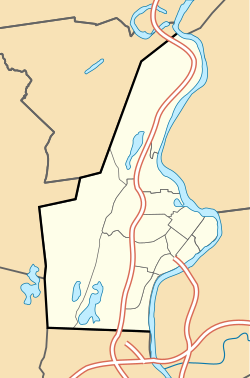
웨스트 홀리요크([3][4]West Holyoke)라고도 불리는 록밸리는 도심에서 약 3마일(4.8km) 떨어진 매사추세츠 주 홀리요크의 이웃으로, 이즈햄튼, 사우샘프턴, 웨스트필드, 웨스트 스프링필드와 접하고 있다.록밸리는 역사적으로 홀리요크가 엘름우드에 이어 두 번째로 오래된 마을로, 1777년 경에 해당하는 묘지가 있으며, 1745년경에는 가족들이 정착했다.[5]해들리 폭포 댐 건설 이전에 웨스트 스프링필드의 제3교구("아일랜드 패리시")의 서쪽 구역에서 유래했다.[6]오늘날 그 인근에는 농업과 습지대에 인접한 많은 현대적 개발 외에도 몇몇 역사적인 연방과 식민지 개척지가 있다.[1][6][7][8]
심지어 20세기까지 이 지역은 농업적인 성격을 유지했지만, 갑작스러운 산업 성장 동안 도시의 나머지 지역들에 의해 이루어진 진보에 뒤처지고 있다고 믿는 주민들의 우려를 받았다.1921년, 서홀리요크 개선 협회는 다수의 관련자들에 의해 시정부 이전에 이웃의 이익을 대변할 목적으로 설립되었다.1955년 록밸리 개선연맹으로 개칭된 이들이 로비를 벌였던 이슈들 중에는 지역 가로등 전기화, 주민센터 건립, 어린이 놀이터 신축 등이 있었다.[4][9][10]협회는 또한 여러 해 동안 많은 이웃의 만찬과 행사를 열었고, 앞서 언급한 목표들 중 많은 것들을 달성한 것은 상대적으로 불명확한 상태에 빠졌다.
1930년 104 보병대의 병사들이 건설한 웨스트필드까지의 보급로가 홀리요크와 웨스트필드 사이의 합동 의식에서 매사추세츠에서 압레몬트 고속도로로 헌납되면서 이 지역은 잠시 국제적인 주목을 받았다.104기는 제1차 세계대전에서 압레몽-라-포레트를 해방시킨 공로로 용맹으로 외국 훈장을 받은 최초의 미군 부대였으며 프랑스 크로익스 드 게레(Croix de Guerre)의 첫 외국인 수령자였다.[11]
추가 읽기
- "HLY.800 Rock Valley Cemetery". Massachusetts Cultural Resource Information System (MACRIS). Massachusetts Historical Commission, Secretary of the Commonwealth of Massachusetts. November 2016.
참조
- ^ a b 공간분석
- ^ a b "Rock Valley, Holyoke, Massachusetts". Geographic Names Information System. United States Geological Survey. Retrieved 13 February 2018.
- ^ "New Hiking Trail Coming to West Holyoke by 2018". WWLP 22 News. September 29, 2016. Archived from the original on July 1, 2018.
- ^ a b [Query- "Rock Valley Emprovement League, Inc.] 매사추세츠 주식회사. 카드 검색, 매사추세츠 연방 법인 카드, 영연방 장관."웨스트 홀리요크 개선 리그, 주식회사...1955년 10월 11일– 록밸리 개선 리그에 이름을 대라."
- ^ "Holyoke Cemetery Being Neglected, Observers Feel, Rock Valley Burying Ground Has Become Weed-Grown Patch, Two Revolutionary Soldiers Rest There". Springfield Republican. Springfield, Mass. June 5, 1938. p. 5.
- ^ a b "MACRIS inventory record for Rock Valley Cemetery, Holyoke". Commonwealth of Massachusetts. Retrieved 2014-06-18.
- ^ "MACRIS inventory record for Nathan Spooner House". Commonwealth of Massachusetts. Retrieved 2014-06-18.
- ^ "MACRIS inventory record for Dank House". Commonwealth of Massachusetts. Retrieved 2014-06-18.
- ^ "Rock Valley Recreation Development Plan Aired". Springfield Union. Springfield, Mass. April 20, 1967. p. 37.
Proposed playground facilities for the Rock Valley area were outlined by Mayor Daniel F. Dibble at a meeting of the Rock Valley Improvement League this week
- ^ "Holyoke- An Early Cotton Mill in the West Holyoke District; West Holyoke of Today and Its Loud Demand on City to Grant It Some Modern Improvements". Springfield Republican. Springfield, Mass. September 18, 1921. p. 10.
- ^ "Apremont Way Between Holyoke and Westfield Is Formally Dedicated". Springfield Republican. Springfield, Mass. June 6, 1930.
[In a letter from the mayor of Apremont] 'I can never thank too much,' it read, 'in the name of the commune of Apremont La Forget [sic] the brave soldiers of the 26th American division and especially the 104th infantry, who really contributed to the deliverance of our village...we have never forgotten you here–everything is a reminder of your generous presence. The village square is named Place d'Holyoke, in memory of the city of that name...the main street is the Rue Belle Skinner, given this honor in memory of the great friend of the commune, a woman with a big heart


