랑스우데
Renswoude랑스우데 | |
|---|---|
.JPG) 랑스우데 성 | |
 깃발  국장 | |
.svg) 위트레흐트의 위치 | |
| 좌표: 52°4°N 화씨 5°33°E / 52.067°N 5.550°E좌표: 52°4′N 5°33′E / 52.067°N 5.550°E/ ° | |
| 나라 | 네덜란드 |
| 주 | 위트레흐트 |
| 정부 | |
| • 차체 | 시의회 |
| • 시장 | 페트라 도른발 반 데르 Vlist (CDA) |
| 면적 | |
| • 합계 | 18.51km2(7.15제곱 mi) |
| • 육지 | 18.40km2(7.10제곱 mi) |
| • 물 | 0.11km2(0.04 sq mi) |
| 표고 | 8m(26ft) |
| 인구 (1919년 1월)[4] | |
| • 합계 | 5,259 |
| • 밀도 | 286/km2(740/sq mi) |
| 시간대 | UTC+1(CET) |
| • 여름(DST) | UTC+2(CEST) |
| 우편번호 | 3927 |
| 지역번호 | 0318 |
| 웹사이트 | www |
렌스워데(Dutch 발음: [rɛnsˈʋʌudud]] ![]() (듣기)는 네덜란드 중부, 위트레흐트 지방에 있는 시·군이다.
(듣기)는 네덜란드 중부, 위트레흐트 지방에 있는 시·군이다.
지형

2015년 6월 렝스워데 시립 네덜란드 지형도
저명인사
- 얀 헨드릭 와싱크(1908~1990)는 네덜란드의 라틴어 학자 겸 학자다.
- Roel Hurbertsen (1948년 출생) 네덜란드의 정치가 겸 돼지농부
- 헨크-잔 홀드(Henk-Jan Hold, 1967년 출생) 배구 선수, 1992년 하계 올림픽 은메달리스트, 1996년 하계 올림픽 단체금메달리스트
- 마아텐 반 가르데렌(1990년 출생) 네덜란드 남자 배구 국가대표팀 선수
갤러리

Jacob van Campen이 Maria Duyst van Voorhout의 남편의 할아버지를 위해 디자인한 교회
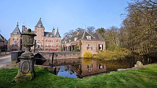
랑스우데 성

겐테후이스, 렌스워데

.jpg)

참조
- ^ "college van B&W" [Board of mayor and aldermen] (in Dutch). Gemeente Renswoude. Archived from the original on 9 April 2014. Retrieved 8 April 2014.
- ^ "Kerncijfers wijken en buurten 2020" [Key figures for neighbourhoods 2020]. StatLine (in Dutch). CBS. 24 July 2020. Retrieved 19 September 2020.
- ^ "Postcodetool for 3927BD". Actueel Hoogtebestand Nederland (in Dutch). Het Waterschapshuis. Retrieved 8 April 2014.
- ^ "Bevolkingsontwikkeling; regio per maand" [Population growth; regions per month]. CBS Statline (in Dutch). CBS. 1 January 2019. Retrieved 1 January 2019.
외부 링크
위트레흐트의 행정 구역 | ||
|---|---|---|
 | ||