푸에르토리코 나구아보
Naguabo, Puerto Rico나구아보 나구아보 시 | |
|---|---|
시와 시 | |
 엘윈케에서 본 나구아보의 모습 | |
 깃발  국장 | |
| 닉네임: "Cuna de Grandes Artistas", "Los Enchumbaos" | |
| 애국가: "미 나가보 델 큐러, 미 나가보 델 소냐르" | |
 나구아보 시티를 강조하는 푸에르토리코의 지도 | |
| 좌표: 18°13′10″N 65°44′12″w / 18.21944°N 65.73667°W좌표: 18°13′10″N 65°44′12″W / 18.21944°N 65.73667°W/ . | |
| 영연방 | |
| 설립됨 | 1821년 7월 15일 |
| 바리오스 | |
| 정부 | |
| • 시장 | 미라이달리즈 로사리오 파간(PD) |
| • 상원 의원. | 7 - 후마카오 |
| • 대표적인 차이. | 35 |
| 면적 | |
| • 합계 | 60.1 sq mi (1955.57km2) |
| • 육지 | 52.1 sq mi(135km2) |
| • 물 | 7.9 sq mi(20.57km2) |
| 인구 (2010) | |
| • 합계 | 26,720 |
| • 밀도 | 440/sq mi(170/km2) |
| 데모닉 | 나가베뇨스 |
| 시간대 | UTC-4(AST) |
| ZIP 코드 | 00718, 00744 |
| 지역 번호 | 787/939 |
| 주요 노선 | |
나구아보(스페인어 발음: [naˈɣwaβo])는 후마카오 북쪽, 리오 그란데와 세이바 남쪽, 라스 피에드라스의 동쪽, 비에케스 통로와 접하는 섬의 동쪽 해안에 위치한 푸에르토리코의 읍·시군이다. 나구아보는 8개의 바리오스와 나구아보 푸에블로(도심 및 행정중심지)에 걸쳐 분포되어 있다. 산후안-카과-과이나보 도시통계구역의 일부다.
나구아보는 푸에르토리코에서 인기 있는 음식인 파스텔로 데 채핀의 출생지로 알려져 있다. 그것은 튀긴 밀가루 반죽에 싸여진 간어다. 파스텔리오스 데 채핀은 섬의 거의 모든 해안에서 발견될 수 있다.
역사
나구아보 마을은 동해안의 협곡 근처에 세워져 1821년에 현재의위치로 이전하였다. 1878년, 나가보에는 다음과 같은 바리오가 있었다. 푸에블로, 마이잘레스, 두케, 마리아나, 퀘브라다 팔마, 다구아오, 산티아고 이 리마, 후카레스, 리오, 페냐 포브레, 리오 블랑코. 1521년, 다과오는 카리브족에 의해 불타버렸다.[1][2][3]
푸에르토리코는 1898년 파리 조약의 조항에 따라 스페인-미국 전쟁의 여파로 스페인에 양도되어 미국의 영토가 되었다. 1899년, 미국은 푸에르토리코에 대한 첫 인구조사를 실시했는데, 나가보의 인구는 10,873명이었다.
지리
나구아보는 푸에르토리코의 남동부에 위치해 있다. 시에서 가장 높은 지점은 시에라 드 루키요에 있는 피코 델 에스테의 고도 3,419피트 (1,042m)이다.[4][5][6]
나구아보에는 리오 블랑코와 리오 에스피리투 산토가 있다.[7]
바리오스

푸에르토리코의 모든 자치구와 마찬가지로 나구아보는 바리오스로 세분된다. 시립 건물, 중앙 광장, 큰 가톨릭 교회는 "엘 푸에블로"라고 불리는 바리오에 위치해 있다.[8][9][10][11]
섹터
바리오스와 서브바리오스는 차례로 [13]더 작은 지역 인구 밀집 지역/종파라 불리는 단일 지역으로 세분된다.[12] 종파의 종류는 보통 부문별로, 우르바니자시온에서 재파르토, 바리아다에서 잔재까지 다양할 수 있다.[14][15][16]
스페셜 커뮤니티
Comunidades Especiales de Puerto Rico(푸에르토리코 특별 공동체)는 시민들이 일정량의 사회적 배제를 경험하고 있는 소외된 공동체다. 지도는 이러한 지역사회가 연방의 거의 모든 자치단체에서 발생한다는 것을 보여준다. 2014년 순위에 오른 742곳 중 나가보에는 다음과 같은 바리오, 커뮤니티, 섹터, 동네가 있었다. 렘파고 인근, 리오, 산티아고 이 리마, 다구아오, 라 플로리다, 바리오푸에블로, 후카레스, 마이잘레스, 리오 블랑코의 카스코 우르바노.[17]
인구통계학
| 역사인구 | |||
|---|---|---|---|
| 인구조사 | Pop. | %± | |
| 1900 | 10,873 | — | |
| 1910 | 14,365 | 32.1% | |
| 1920 | 15,788 | 9.9% | |
| 1930 | 18,212 | 15.4% | |
| 1940 | 19,180 | 5.3% | |
| 1950 | 21,019 | 9.6% | |
| 1960 | 17,195 | −18.2% | |
| 1970 | 17,996 | 4.7% | |
| 1980 | 20,617 | 14.6% | |
| 1990 | 22,620 | 9.7% | |
| 2000 | 23,753 | 5.0% | |
| 2010 | 26,720 | 12.5% | |
| 2020 | 23,386 | −12.5% | |
| 미국 십수년 인구[18] 조사 1899년 (1990년 ~[19] 1900년) 1910년[20] 1930-1950[21] 1960-2000[22] 2010[10] 2020[23] | |||
관광업
랜드마크 및 관심장소

나구아보에는 31개의 해변이 있다.[24] 나구아보의 주요 명소는 다음과 같다.
- 알고돈스 키
- 엘윈케 국유림(PR 주도로 191을 경유하는 남쪽) - 도로 폐쇄로 인해 KM 13(마일 표식 8.1)에서 폐쇄됨(대략)
- 나구아보 해변
- 푼타 리마 비치
- 라몬 리베로 "디플로" 기념비
- 트로피컬 비치
- 유델미 센터
- 페드로 플로레스 기념비
- 후카레스 워터프런트(엘 말레콘 - 보드워크)
- 주요 도시 광장(플라자 데 레크리에소)
- 샤르코 엘 히피[25]
문화
축제 및 행사
나구아보는 10월에 수호 성인 축제를 연다. 피에스타스 프리스트랄레스 데 누에스트라 비르겐 델 로사리오(Fiestas Patrantales de Nuestra Virgen del Rosario)는 일반적으로 퍼레이드, 게임, 장인, 놀이 기구, 놀이 기구, 지역 음식, 라이브 엔터테인먼트를 특징으로 하는 종교적이고 문화적인 축하 행사다.[6]
나구아보에서 기념되는 다른 축제와 행사는 다음과 같다.
이코노미
기호
그 자치단체는 공식 깃발과 무장을 가지고 있다.[26]
깃발
이 자치단체에는 국기가 있다.[27]
국장
이 자치단체는 무장을 하고 있다.[27]
교통
나구아보에는 대중교통이 있다. 오전 6시부터 '피시코레' 버스를 이용해 운행한다.[28][29] 나구아보에는 52개의 다리가 있다.[30]
정부
나구아보는 시장이 이끈다. 2021년 1월 2일, 민중당(푸에르토리코)의 미라이달리즈 로사리오 파간(Miraidaliz Rosario Pagan)이 나구아보 시장 임기를 시작했다.[31]
나구아보에 관한 책
카르멜로 로사리오 나탈의 히스토리아 드 나가보
갤러리
나구아보의 리오 블랑코 저수지

나구아보의 거리

나구아보의 주택가

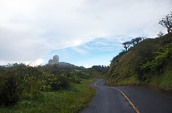
나구아보에서 세이바까지의 고속도로
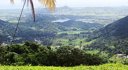
엘윈케 정상에서 푸에르토리코 북동부
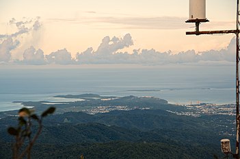
나구아보의 레이더탑


.jpg)
참고 항목
참조
- ^ 드 코르도바, 페드로 토마스, 암레비아스 지오그라피카스, 히스토리카스, 에코노미카스 이 에스타디스트라스 데 라 이사 드 푸에르토리코, 1831년 토모 2, 파그 299
- ^ de Ubeda y Delgado, Manuel (1878). Puerto Rico: Estudio Histórico, Geográfico y Estadístico de la Misma. HathiTrust. p. 277. Retrieved 29 October 2020.
- ^ "La Historia de Puerto Rico a través de sus Barrios: Daguao de Naguabo [The History of Puerto Rico through its Barrios: Daguao in Naguabo]" (video). www.pbslearningmedia.org (in Spanish). Fundación Puertorriqueña de las Humanidades. Retrieved 29 August 2020.
- ^ "Pico del Este (1611654)". www.usgs.gov/. Retrieved 2021-09-11.
- ^ "Barrios de Puerto Rico: Barrio Daguao de Naguabo". PBS Learning Media. Florida PBS. Archived from the original on 1 December 2017. Retrieved 27 November 2017.
- ^ a b "Naguabo Municipality". enciclopediapr.org. Fundación Puertorriqueña de las Humanidades (FPH). Archived from the original on 2017-11-21. Retrieved 2019-03-20.
- ^ "Rescatan a seis personas por inundaciones en Naguabo [Six people rescued after flooding in Naguabo]". El Nuevo Día (in Spanish). 30 July 2019. Retrieved 29 August 2020.
- ^ Picó, Rafael; Buitrago de Santiago, Zayda; Berrios, Hector H. Nueva geografía de Puerto Rico: física, económica, y social, por Rafael Picó. Con la colaboración de Zayda Buitrago de Santiago y Héctor H. Berrios. San Juan Editorial Universitaria, Universidad de Puerto Rico,1969. Archived from the original on 2018-12-26. Retrieved 2019-01-12.
- ^ Gwillim Law (20 May 2015). Administrative Subdivisions of Countries: A Comprehensive World Reference, 1900 through 1998. McFarland. p. 300. ISBN 978-1-4766-0447-3. Retrieved 25 December 2018.
- ^ a b Puerto Rico:2010:population and housing unit counts.pdf (PDF). U.S. Dept. of Commerce Economics and Statistics Administration U.S. Census Bureau. 2010. Archived (PDF) from the original on 2017-02-20. Retrieved 2018-12-27.
- ^ "Map of Naguabo at the Wayback Machine" (PDF). Archived from the original (PDF) on 2018-03-24. Retrieved 2018-12-29.
- ^ a b "US Census Barrio-Pueblo definition". factfinder.com. US Census. Archived from the original on 13 May 2017. Retrieved 5 January 2019.
- ^ "P.L. 94-171 VTD/SLD Reference Map (2010 Census): Naguabo Municipio, PR" (PDF). www2.census.gov. U.S. DEPARTMENT OF COMMERCE Economics and Statistics Administration U.S. Census Bureau. Archived (PDF) from the original on 22 August 2020. Retrieved 22 August 2020.
- ^ "Agencia: Oficina del Coordinador General para el Financiamiento Socioeconómico y la Autogestión (Proposed 2016 Budget)". Puerto Rico Budgets (in Spanish). Archived from the original on 28 June 2019. Retrieved 28 June 2019.
- ^ Rivera Quintero, Marcia (2014), El vuelo de la esperanza: Proyecto de las Comunidades Especiales Puerto Rico, 1997-2004 (first ed.), San Juan, Puerto Rico Fundación Sila M. Calderón, ISBN 978-0-9820806-1-0
- ^ "Leyes del 2001". Lex Juris Puerto Rico (in Spanish). Archived from the original on 14 September 2018. Retrieved 24 June 2020.
- ^ Rivera Quintero, Marcia (2014), El vuelo de la esperanza:Proyecto de las Comunidades Especiales Puerto Rico, 1997-2004 (Primera edición ed.), San Juan, Puerto Rico Fundación Sila M. Calderón, p. 273, ISBN 978-0-9820806-1-0
- ^ "U.S. Decennial Census". United States Census Bureau. Archived from the original on February 13, 2020. Retrieved September 21, 2017.
- ^ "Report of the Census of Porto Rico 1899". War Department Office Director Census of Porto Rico. Archived from the original on July 16, 2017. Retrieved September 21, 2017.
- ^ "Table 3-Population of Municipalities: 1930 1920 and 1910" (PDF). United States Census Bureau. Archived (PDF) from the original on August 17, 2017. Retrieved September 21, 2017.
- ^ "Table 4-Area and Population of Municipalities Urban and Rural: 1930 to 1950" (PDF). United States Census Bureau. Archived (PDF) from the original on August 30, 2015. Retrieved September 21, 2014.
- ^ "Table 2 Population and Housing Units: 1960 to 2000" (PDF). United States Census Bureau. Archived (PDF) from the original on July 24, 2017. Retrieved September 21, 2017.
- ^ Bureau, US Census. "PUERTO RICO: 2020 Census". The United States Census Bureau. Retrieved 2021-08-25.
- ^ "Las 1,200 playas de Puerto Rico [The 1200 beaches of Puerto Rico]". Primera Hora (in Spanish). April 14, 2017. Archived from the original on December 12, 2019. Retrieved December 12, 2019.
- ^ "Naguabo está lindo para la foto" [Naguabo is pretty for photos]. El Nuevo Día (in Spanish). 2021-09-05. Retrieved 2021-09-05.
- ^ "Ley Núm. 70 de 2006 -Ley para disponer la oficialidad de la bandera y el escudo de los setenta y ocho (78) municipios". LexJuris de Puerto Rico (in Spanish). Retrieved 2021-06-15.
- ^ a b "NAGUABO". LexJuris (Leyes y Jurisprudencia) de Puerto Rico (in Spanish). 19 February 2020. Archived from the original on 19 February 2020. Retrieved 22 September 2020.
- ^ María Isabel Quiñones Arocho (2004). El fin del reino de lo propio ensayos de antropologia cultural. Siglo XXI. pp. 104–. ISBN 968-23-2494-7. Archived from the original on 2020-08-22. Retrieved 2019-02-21.
- ^ Garcia, Themis. "Understanding Collective Transportation". Medium. Archived from the original on 22 February 2019. Retrieved 21 February 2019.
- ^ "Naguabo Bridges". National Bridge Inventory Data. US Dept. of Transportation. Archived from the original on 22 February 2019. Retrieved 20 February 2019.
- ^ "Miraidaliz Rosario Pagán". Ballotpedia. 2020-11-03. Retrieved 2021-02-20.