말리에리아
Marliéria말리에리아 | |
|---|---|
시 | |
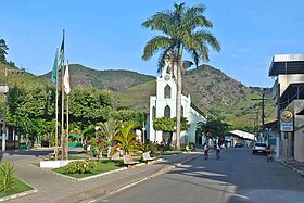
 우리의 슬픔의 여인 어머니 교회를 배경으로 한 JK 광장의 모습 | |
| 좌표:19°42°43°S 42°43′55″w/19.71194°S 42.73194°W | |
| 나라 | |
| 지역 | 남동부 |
| 주 | 미나스 제라이스 |
| 메소레지온 | 베일두 리오 도스 |
| 인구 (2020 [1]) | |
| • 합계 | 4,034 |
| 시간대 | UTC-3(BRT) |
말리에리아는 브라질 남동부 미나스 제라이스 주에 있는 자치 단체다.[2][3][4][5]
이 자치단체는 1944년 미나스제라이스 최초의 주 단위 보존 단위인 3만5970헥타르(8만8900에이커)의 리오 도스 주립공원의 일부를 포함하고 있다.[6]
참고 항목
참조
- ^ IBGE 2020
- ^ "Divisão Territorial do Brasil" (in Portuguese). Divisão Territorial do Brasil e Limites Territoriais, Instituto Brasileiro de Geografia e Estatística (IBGE). July 1, 2008. Retrieved December 17, 2009.
- ^ "Estimativas da população para 1º de julho de 2009" (PDF) (in Portuguese). Estimativas de População, Instituto Brasileiro de Geografia e Estatística (IBGE). August 14, 2009. Retrieved December 17, 2009.
- ^ "Ranking decrescente do IDH-M dos municípios do Brasil" (in Portuguese). Atlas do Desenvolvimento Humano, Programa das Nações Unidas para o Desenvolvimento (PNUD). 2000. Archived from the original on October 3, 2009. Retrieved December 17, 2009.
- ^ "Produto Interno Bruto dos Municípios 2002-2005" (PDF) (in Portuguese). Instituto Brasileiro de Geografia e Estatística (IBGE). December 19, 2007. Archived from the original (PDF) on October 2, 2008. Retrieved December 17, 2009.
- ^ Parque Estadual do Rio Doce (in Portuguese), IEF: Instituto Estadual de Florestas MG, retrieved 2017-02-06


