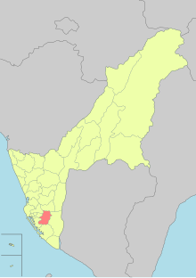
펑산 구
Fongshan District퐁산 시 鳳山區 호잔, 펑산 | |
|---|---|
| 펑산[1] 구 | |
 | |
 퐁산 구 위치 | |
| 좌표: 22°38˚N 화씨 120°21°E / 22.633°N 120.350°E좌표: 22°38′N 120°21′E / 22.633°N 120.350°E/ ° | |
| 나라 | 중화민국(대만) |
| 시 | 가오슝 |
| 면적 | |
| • 합계 | 26.76km2(10.33 sq mi) |
| 인구 (2016년 1월) | |
| • 합계 | 356,507 |
| • 밀도 | 13,000/km2(35,000/sq mi) |
| 시간대 | UTC+8(전국 표준시) |
| 웹사이트 | fsdo |

펑산[1][2][3][4][5][6][7][8][9] 구(중국어: 鳳山區; 하뉴 피닌: 펑산큐; 통용피닌: 펑산 시우; pe오에-:: ō-so-so-k-k-k-k-k-k-k-k)은 타이완의 가오슝 남부에 위치한 구이다. 퐁산은 가오슝 행정중심지 중 하나로 중국 육군사관학교가 소재하고 있다. 퐁산에는 현재 3개 부대가 주둔하고 있다. 중국 육군사관학교와 R.O.C. 둘 다. 육군 보병학교는 중국 본토에서 이주하여 1950년에 이곳에 다시 설립되었다. 충청군예비학교는 1976년에 설립되었다. 이 세 단위는 이전에는 주요 경제 동력이었으나 퐁산이 핑둥 시와 가오슝 시의 접속사로 자리를 잡으면서 그 중요성은 점차 줄어드는 것으로 보인다.
도시의 테두리나 외곽에는 여러 개의 공업지대가 있지만, 퐁산의 주요 생활양식은 매우 주거적인 것 같다. 가오슝 도심 인근에 경제적 무게의 이동으로 인해 많은 아파트가 지어졌다. 대만의 대부분의 지역과 마찬가지로, 도시 내에 많은 야시장이 산재해 있다. 대부분의 야시장은 새벽 2시까지 운영된다. 그들 중 몇몇은 다른 요일에 장사를 하지만, 다른 몇몇은 일년 내내 일을 한다. 그들 중 일부는 임시적인 반면, 다른 일부는 영구적인 시설이 되었다.
역사
네덜란드 시대에는 현재의 퐁산의 위치를 퐁소야(린변, 핑둥 참조)라고 불렀는데, 마카타오 8개 마을로 이루어져 있으며 대만에서 가장 인구가 많은 지역 중 하나이다.
청 왕조
청 통치 기간 동안 펑산 구)[zh에는 타이난 남쪽(당시 "대만후"라 불림)과 산의 서쪽이 포함되었다. 1875년 펑산 현 남부는 헝춘 구로 분리되었다.
일본 제국
1901년, 일본 통치 기간 중 호잔 초(일본어: 鳳山廳)는 20개의 지방 행정 기관 중 하나였다. 1904년 인구조사에 따르면 호잔 읍의 인구는 5,750명인 반면 호잔 구는 173,016명의 인구를 가지고 있었다.[10] 1909년 이 부대는 타이난 조(太南an)로 합병되었다. 1920년부터 1945년까지 현 체제 하에서 다카오 현 호잔 구(鳳山區)의 호잔 구(湖山區)에서 호잔 타운(山山街)을 관리하였다. 20세기 초 식민지 정부가 타카오 항만을 개발하기 시작한 이후 퐁산의 중요성은 쇠퇴하고 있었다.
중화민국
퐁산은 가오슝 현의 수도로, 1945년 도시 읍으로 설립되었다. 1972년 7월 1일 군 관할 도시로 승격되었다. 2010년 12월 24일 지구로 승격되어 링야 구와 함께 그 때부터 가오슝 시의 시가지로 자리 잡고 있다.
행정 구역
The district consists of Xiankou, Chenggong, Guangming, Xingzhong, Nanxing, Hede, Fenggang, Zhonghe, Zhenbei, Xianya, Wenying, Zhenxi, Zhentung, Beiding, Zhongzheng, Zhennan, Laoye, Ruizhu, Zhongyi, Chengyi, Xinxing, Haiguang, Zhongcheng, Xinjia, Wuhan, Zhengyi, Yijia, Fuxing, Tungmen, Ruixing, Tianxing, Xinjiang, Guotai, Fengtung, Xinfu, Guoguang, Guolong, Wende, Guobei, Caogong, 싱런, Wufu, Zhongxiao, Shengming, Hexing, Xiehe, 원산, 푸청. 중국 허베이 성 청더 피서 산장, 싼민, 베이먼, Fujia, 난청, Wenhua, 데이드, Wusong, Wenheng, Wenfu, Chengxin, Chengzhi, Guofu, 우칭, 하이양 시, Xinwu, 신러, 신타이 시, Zhonglun, 중융, Zhongmin, Erjia, 룽청. 중국, 푸룽, Shanmei, 난허, Fuxiang과 보안 마을이다.[11]
기후
퐁산은 열대지방에 있다. 평균 온도는 23 °C이다. 평균 강수량은 1500~2000mm이다.
정부기관
교육
관광명소
- 솽치정(마주)사
- 가오공사
- 청황사
- 청란성
- 다동예술회관
- 동변문
- 동푸 대교
- 펑산룽산사
- 펑산톈궁사
- 퐁산 스타디움
- 퐁산 지역 문화 박물관
- 펑이 자습 학원
- 구 일본 해군 펑산 통신센터
- 가오슝 시립 교향악단
- 핑청 요새
- 솽시 정
- 쉰퐁 요새
- 웨이우잉 메트로폴리탄 파크
- 중화거리 야시장
교통
도로
- 국도 제1호선(대만)
- 지방도 제1호선(대만)
- 지방도 제1호선 - 슈(대만)
- 지방도 제25호선(대만)
- 지방도 88호선(대만)
레일즈
주목할 만한 원주민
참고 항목
메모들
- ^ Jump up to: a b "Administrative Districts". Kaohsiung Municipal Government. 30 September 2016. Retrieved 4 April 2017.
Fongshan District:
- ^ "Water Resources Bureau". 高雄市政府 Kaohsiung City Government. 21 November 2016. Retrieved 15 September 2020.
Moreover, forward command center will be established in Fongshan, Cishan, and Gangshan when typhoon or torrential rain occurs in order to aggregate information and dispatch human resources.
- ^ "Fongshan History". Welcome to Fongshan District Office. Retrieved 24 July 2019.
On December 25, 2010, Kaohsiung City and County were consolidated, and the Office was renamed as Fongshan District Office of Kaohsiung City.
- ^ "Welcome to Fongshan District First Household Registration Office, Kaohsiung City". Fongshan District First Household Registration Office. Retrieved 24 July 2019.
- ^ 미국 국립 지리공간정보국(National Geospatial-Intelligence Agency, GEOnet Names Server)의 Fongshan(변수 - V)
- ^ Chen Yu-fu; Jonathan Chin (19 June 2019). "Commission researches White Terror-era prisons". Taipei Times. Retrieved 24 July 2019.
The euphemistically named “Fongshan Guesthouse” (鳳山招待所) in Kaoshiung’s Fongshan District (鳳山) is one of three intact prison facilities used in the city during the White Terror era, it said.
- ^ M. Chuang (19 June 2019). "Second Wave of Dengue Cluster Infections Begins 高雄新增1登革熱病例 疑群聚疫情第2波". Public Television Service. Retrieved 24 July 2019.
With the outbreak spreading, Fongshan District is on high alert due to its proximity to Sanmin District. The chief of Fongshan's Guoguang Borough says the military was supposed to disinfect the borough but never showed up.
- ^ Chuan-Hung Chiu, Tzai-Hung Wen, Lung-Chang Chien, Hwa-Lung Yu (10 October 2014). "A Probabilistic Spatial Dengue Fever Risk Assessment by a Threshold-Based-Quantile Regression Method". PLoS ONE. 9 (10): e106334. doi:10.1371/journal.pone.0106334. PMC 4193740. PMID 25302582.
Fongshan District, located to the southeast of Kaohsiung City and covering an area of 26 km2, was the former capital of Kaohsiung County and has a population of approximately 36 000.
CS1 maint: 작성자 매개변수 사용(링크) - ^ 1.7-鄉鎮市區戶口數 [Population for Township and District]. Ministry of the Interior (in Chinese and English). August 2020. Retrieved 21 September 2020.
鳳山區 Fongshan District 26.7590 144,316 359,835 175,699 184,136 95.42 2.49 13,447
- ^ 타케코시(1907), 페이지 199-200.
- ^ https://www.cec.gov.tw/pc/en/TV/nm64000001200000000.html
참조
- Takekoshi, Yosaburō (1907). Japanese rule in Formosa. London, New York, Bombay and Calcutta: Longmans, Green, and co. OCLC 753129. OL 6986981M.
외부 링크
| 위키미디어 커먼즈에는 가오슝 펑산 구와 관련된 미디어가 있다. |
- ^ Sarah Shair-Rosenfield (November 2020). "Taiwan combined" (PDF). The University of North Carolina at Chapel Hill. Retrieved 29 May 2021.


