세람해
| 세람해 | |
|---|---|
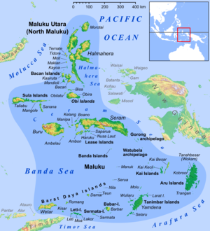
 동남아시아 내의 세라마 바다의 위치. | |
| 좌표 | 2°20°S 동경 128도00도 / 2.333°S 128.000°E좌표: 2°20′S 128°00′E / 2.333°S 128.000°E/ |
| 유형 | 바다 |
| 네이티브 이름 | 인도네시아어: 라우트 세람 |
| 분지 국가 | 인도네시아 |
| 표면적 | 12,000km2(4,600sq mi) |

세람해 또는 세라마해(인도네시아어: Laut Seram)는 인도네시아의 산재한 섬들 사이에 있는 여러 작은 바다 중 하나이다. 부루와 세람 사이에 위치한 약 1만 2천 평방 킬로미터(4,600 평방 미)의 면적을 가진 태평양의 한 구역으로, 한때 남몰루카라고 불리던 섬들 중 두 곳이다. 이 섬들은 육두구, 정향, 흑후추 등 향신료로 쓰이기 위해 오랫동안 탐내던 식물의 자생지로, 이들을 둘러싼 바다는 뱃길이 분주했다. 세람해는 열대지방의 여러 종과 많은 다른 물고기들의 서식지이기도 하다. 다른 많은 작은 인도네시아 바다와 마찬가지로 세람해는 암석이 많고 지질학적으로 매우 활발하다.
범위
국제수로기구(IHO)는 세람해를 동인도 제도의 해역 중 하나로 규정하고 있다. 국제수로기구는 그 한계를 다음과 같이 정의한다.[1]
북부와 북동부에. A line from Tanjong Dehekolano, the Eastern extreme of the Soela [Sula] Islands to the Western extreme of Obi, along its Southern coast to Tanjung Serammaloleo its Eastern extreme, thence through Tobalai, Kekeh, Pisang and Kofiau Islands to Tanjong Sele (1°26′S 130°55′E / 1.433°S 130.917°E), the Western point of New Guinea, down 카루파까지의 해안(3°51.5)′S 133°27′E / 3.8583°S 133.450°E).
남동쪽이요. 뉴기니의 카루파에서 풀라우 아디의 남동쪽 극지방에 이르는 선으로, 그 다음 풀라우 누후유트[카이베사르]의 북쪽 지점인 탄중보랑(5°17′S 133°09′E / 5.283°S 133.150°E/ °E.
남서부와 남부에. From the Northern point of pulau Nuhuyut (Groot Kai) through the Watubela and Gorong Islands to the Southeastern extreme of Ceram, along its Northern shore to Tanjung Tandurubesar , the Northwest point, thence a line to Tanjung Baturuhan, the Northern extreme of Buru [Buru], and along the coast to Tanjung Palpetu, the Northwest point of the Island.
서양에서. A line from Tanjung Palpetu to Tanjung Waka, the Southern point of pulau Sanana, through this island to its Northern point, thence across the Mangoli Strait to the South coast of Mangole (Sula Islands) in [1°56′S 125°55′E / 1.933°S 125.917°E].
추가 읽기
- 페어브리지, R. E. (1966년) 해양학 백과사전. 뉴욕: 할스테드.
- 왕, 제임스 C. F. (1992) 해양 정치와 법률에 관한 안내서. 뉴욕: 그린우드 프레스.
참조
- ^ "Limits of Oceans and Seas, 3rd edition" (PDF). International Hydrographic Organization. 1953. Retrieved 28 December 2020.


