카헤르보시나
Caherboshina카헤르보시나 캐세어 보사인 | |
|---|---|
타운랜드 | |
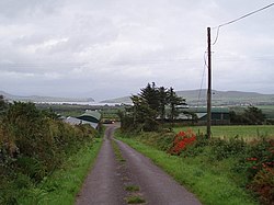
 카헤르보시나의 농지와 풍경 | |
| 좌표:52°08′43§ N 10°20′16″w/52.1453°N 10.3378°W좌표: 52°08°43°N 10°20°16°W / 52.1453°N 10.3378°W / | |
| 나라 | 아일랜드 |
| 지방 | 먼스터 |
| 자치주 | 케리 주 |
| 지역 | |
| • 합계 | 1.8km2(0.7평방마일) |
| 시간대 | UTC+0(WET) |
| • 여름 (DST) | UTC-1(IST(WEST)) |
| 아일랜드 그리드 참조 | Q401030 |
카헤르보시나(아일랜드어: Cathair Bö [2]Sine)는 [3]아일랜드 케리 주 딩글(다이건 이취이스)에서 약 4km 떨어진 곳에 위치한 도시입니다.그 위치는 아일랜드 최서단 육지 코르차 뒤브네(딩글 반도)[citation needed]의 거의 위도 중심에 있다.
레퍼런스
- ^ "Caherboshina Townland, Co. Kerry". townlands.ie. Retrieved 25 December 2020.
- ^ "Cathair Bó Sine / Caherboshina". logainm.ie. Irish Placenames Commission. Retrieved 25 December 2020.
- ^ General Alphabetical Index to the Townlands and Towns, Parishes, and Baronies of Ireland: Based on the Census of Ireland for the Year 1851, Volume 8. 1984. p. 182. ISBN 9780806310527.


